You are here: Home > Network List > IW - Intermountain West Stations List
> Station LOHW Long Hollow, Wyoming, USA > Earthquake Result Viewer
LOHW Long Hollow, Wyoming, USA - Earthquake Result Viewer
| Earthquake location: |
Tonga Islands |
| Earthquake latitude/longitude: |
-21.4/-173.3 |
| Earthquake time(UTC): |
2014/09/04 (247) 05:33:46 GMT |
| Earthquake Depth: |
12 km |
| Earthquake Magnitude: |
6.0 MWB |
| Earthquake Catalog/Contributor: |
NEIC PDE/NEIC COMCAT |
|
| Network: |
IW Intermountain West |
| Station: |
LOHW Long Hollow, Wyoming, USA |
| Lat/Lon: |
43.61 N/110.60 W |
| Elevation: |
2121 m |
|
| Distance: |
86.5 deg |
| Az: |
40.27 deg |
| Baz: |
236.031 deg |
| Ray Param: |
0.04402876 |
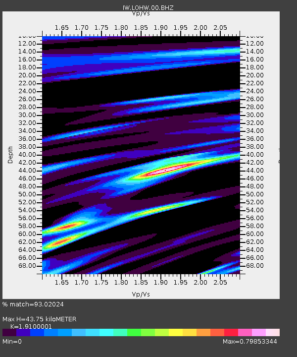
| Estimated Moho Depth: |
43.75 km |
| Estimated Crust Vp/Vs: |
1.91 |
| Assumed Crust Vp: |
6.207 km/s |
| Estimated Crust Vs: |
3.25 km/s |
| Estimated Crust Poisson's Ratio: |
0.31 |
|
| Radial Match: |
93.02024 % |
| Radial Bump: |
374 |
| Transverse Match: |
88.747505 % |
| Transverse Bump: |
400 |
| SOD ConfigId: |
790520 |
| Insert Time: |
2014-09-18 06:02:29.622 +0000 |
| GWidth: |
2.5 |
| Max Bumps: |
400 |
| Tol: |
0.001 |
|

Signal To Noise
| Channel | StoN | STA | LTA |
| IW:LOHW:00:BHZ:20140904T05:45:57.390022Z | 16.204615 | 6.5030116E-7 | 4.013061E-8 |
| IW:LOHW:00:BH1:20140904T05:45:57.390022Z | 2.5624697 | 1.5436034E-7 | 6.023889E-8 |
| IW:LOHW:00:BH2:20140904T05:45:57.390022Z | 3.726247 | 2.1280381E-7 | 5.710942E-8 |
| Arrivals |
| Ps | 6.5 SECOND |
| PpPs | 20 SECOND |
| PsPs/PpSs | 27 SECOND |


