You are here: Home > Network List > PB - Plate Boundary Observatory Borehole Seismic Network Stations List
> Station B088 skyoks088bcs2007, Anza, CA, USA > Earthquake Result Viewer
B088 skyoks088bcs2007, Anza, CA, USA - Earthquake Result Viewer
| Earthquake location: |
Tonga Islands |
| Earthquake latitude/longitude: |
-21.4/-173.3 |
| Earthquake time(UTC): |
2014/09/04 (247) 05:33:46 GMT |
| Earthquake Depth: |
12 km |
| Earthquake Magnitude: |
6.0 MWB |
| Earthquake Catalog/Contributor: |
NEIC PDE/NEIC COMCAT |
|
| Network: |
PB Plate Boundary Observatory Borehole Seismic Network |
| Station: |
B088 skyoks088bcs2007, Anza, CA, USA |
| Lat/Lon: |
33.37 N/116.62 W |
| Elevation: |
1404 m |
|
| Distance: |
76.7 deg |
| Az: |
45.904 deg |
| Baz: |
233.113 deg |
| Ray Param: |
0.050822794 |
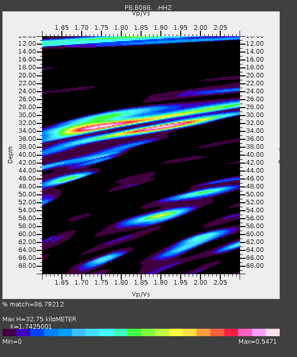
| Estimated Moho Depth: |
32.75 km |
| Estimated Crust Vp/Vs: |
1.74 |
| Assumed Crust Vp: |
6.264 km/s |
| Estimated Crust Vs: |
3.595 km/s |
| Estimated Crust Poisson's Ratio: |
0.25 |
|
| Radial Match: |
86.79212 % |
| Radial Bump: |
400 |
| Transverse Match: |
70.37388 % |
| Transverse Bump: |
400 |
| SOD ConfigId: |
790520 |
| Insert Time: |
2014-09-18 06:07:57.380 +0000 |
| GWidth: |
2.5 |
| Max Bumps: |
400 |
| Tol: |
0.001 |
|

Signal To Noise
| Channel | StoN | STA | LTA |
| PB:B088: :HHZ:20140904T05:45:05.893989Z | 18.016888 | 4.245127E-8 | 2.3561935E-9 |
| PB:B088: :HH1:20140904T05:45:05.893989Z | 3.7521718 | 6.4165357E-9 | 1.7100857E-9 |
| PB:B088: :HH2:20140904T05:45:05.893989Z | 2.518421 | 4.3311705E-9 | 1.7197961E-9 |
| Arrivals |
| Ps | 4.0 SECOND |
| PpPs | 14 SECOND |
| PsPs/PpSs | 18 SECOND |


