You are here: Home > Network List > TA - USArray Transportable Network (new EarthScope stations) Stations List
> Station A04D Lummi Island, WA, USA > Earthquake Result Viewer
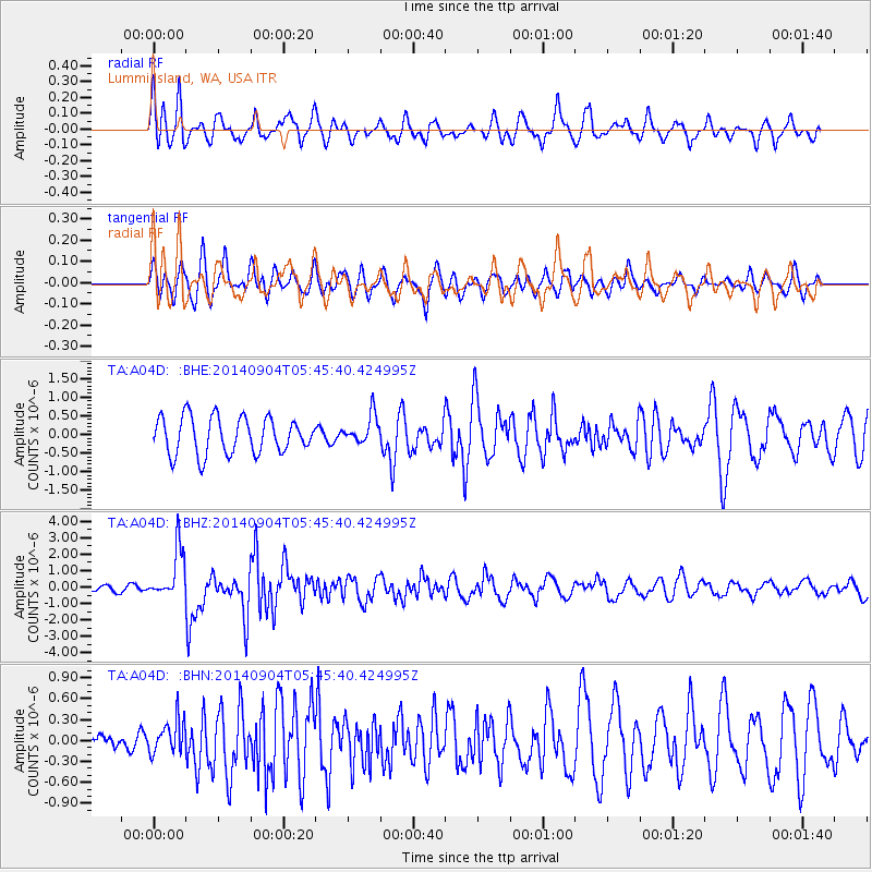
A04D Lummi Island, WA, USA - Earthquake Result Viewer
*The percent match for this event was below the threshold and hence no stack was calculated.
| Earthquake location: |
Tonga Islands |
| Earthquake latitude/longitude: |
-21.4/-173.3 |
| Earthquake time(UTC): |
2014/09/04 (247) 05:33:46 GMT |
| Earthquake Depth: |
12 km |
| Earthquake Magnitude: |
6.0 MWB |
| Earthquake Catalog/Contributor: |
NEIC PDE/NEIC COMCAT |
|
| Network: |
TA USArray Transportable Network (new EarthScope stations) |
| Station: |
A04D Lummi Island, WA, USA |
| Lat/Lon: |
48.72 N/122.71 W |
| Elevation: |
13 m |
|
| Distance: |
83.1 deg |
| Az: |
31.006 deg |
| Baz: |
226.459 deg |
| Ray Param: |
$rayparam |
*The percent match for this event was below the threshold and hence was not used in the summary stack. |
|
| Radial Match: |
78.7636 % |
| Radial Bump: |
400 |
| Transverse Match: |
69.0221 % |
| Transverse Bump: |
400 |
| SOD ConfigId: |
790520 |
| Insert Time: |
2014-09-18 06:10:38.638 +0000 |
| GWidth: |
2.5 |
| Max Bumps: |
400 |
| Tol: |
0.001 |
|
Signal To Noise
| Channel | StoN | STA | LTA |
| TA:A04D: :BHZ:20140904T05:45:40.424995Z | 6.30587 | 1.5307646E-6 | 2.4275232E-7 |
| TA:A04D: :BHN:20140904T05:45:40.424995Z | 0.9469934 | 2.4239796E-7 | 2.5596583E-7 |
| TA:A04D: :BHE:20140904T05:45:40.424995Z | 0.79302037 | 3.8839218E-7 | 4.897632E-7 |
| Arrivals |
| Ps | |
| PpPs | |
| PsPs/PpSs | |


