You are here: Home > Network List > TA - USArray Transportable Network (new EarthScope stations) Stations List
> Station J01E Myrtle Point, OR, USA > Earthquake Result Viewer
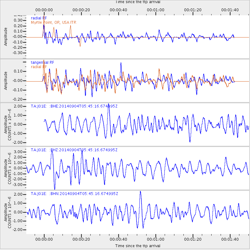
J01E Myrtle Point, OR, USA - Earthquake Result Viewer
*The percent match for this event was below the threshold and hence no stack was calculated.
| Earthquake location: |
Tonga Islands |
| Earthquake latitude/longitude: |
-21.4/-173.3 |
| Earthquake time(UTC): |
2014/09/04 (247) 05:33:46 GMT |
| Earthquake Depth: |
12 km |
| Earthquake Magnitude: |
6.0 MWB |
| Earthquake Catalog/Contributor: |
NEIC PDE/NEIC COMCAT |
|
| Network: |
TA USArray Transportable Network (new EarthScope stations) |
| Station: |
J01E Myrtle Point, OR, USA |
| Lat/Lon: |
43.16 N/123.93 W |
| Elevation: |
128 m |
|
| Distance: |
78.6 deg |
| Az: |
34.477 deg |
| Baz: |
226.133 deg |
| Ray Param: |
$rayparam |
*The percent match for this event was below the threshold and hence was not used in the summary stack. |
|
| Radial Match: |
63.42526 % |
| Radial Bump: |
400 |
| Transverse Match: |
55.94462 % |
| Transverse Bump: |
400 |
| SOD ConfigId: |
790520 |
| Insert Time: |
2014-09-18 06:11:29.114 +0000 |
| GWidth: |
2.5 |
| Max Bumps: |
400 |
| Tol: |
0.001 |
|
Signal To Noise
| Channel | StoN | STA | LTA |
| TA:J01E: :BHZ:20140904T05:45:16.674995Z | 1.9375541 | 1.4161379E-6 | 7.3088944E-7 |
| TA:J01E: :BHN:20140904T05:45:16.674995Z | 1.4228637 | 3.7561628E-7 | 2.6398612E-7 |
| TA:J01E: :BHE:20140904T05:45:16.674995Z | 1.738898 | 1.0461403E-6 | 6.01611E-7 |
| Arrivals |
| Ps | |
| PpPs | |
| PsPs/PpSs | |


