You are here: Home > Network List > UU - University of Utah Regional Network Stations List
> Station KNB Kanab, UT, USA > Earthquake Result Viewer
KNB Kanab, UT, USA - Earthquake Result Viewer
| Earthquake location: |
Tonga Islands |
| Earthquake latitude/longitude: |
-21.4/-173.3 |
| Earthquake time(UTC): |
2014/09/04 (247) 05:33:46 GMT |
| Earthquake Depth: |
12 km |
| Earthquake Magnitude: |
6.0 MWB |
| Earthquake Catalog/Contributor: |
NEIC PDE/NEIC COMCAT |
|
| Network: |
UU University of Utah Regional Network |
| Station: |
KNB Kanab, UT, USA |
| Lat/Lon: |
37.02 N/112.82 W |
| Elevation: |
1715 m |
|
| Distance: |
81.3 deg |
| Az: |
44.767 deg |
| Baz: |
235.077 deg |
| Ray Param: |
0.047653347 |
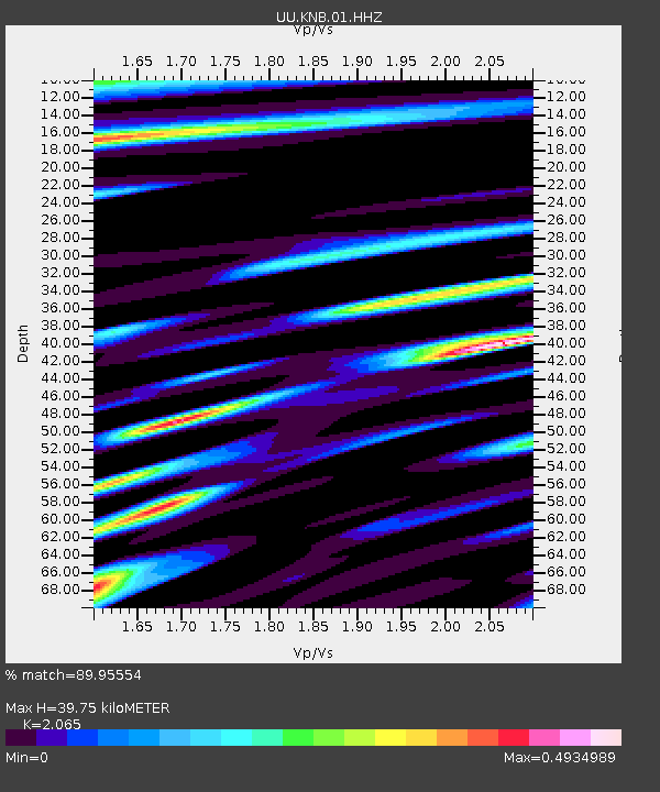
| Estimated Moho Depth: |
39.75 km |
| Estimated Crust Vp/Vs: |
2.07 |
| Assumed Crust Vp: |
6.194 km/s |
| Estimated Crust Vs: |
3.0 km/s |
| Estimated Crust Poisson's Ratio: |
0.35 |
|
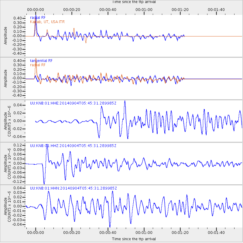
| Radial Match: |
89.95554 % |
| Radial Bump: |
356 |
| Transverse Match: |
86.01138 % |
| Transverse Bump: |
400 |
| SOD ConfigId: |
790520 |
| Insert Time: |
2014-09-18 06:15:55.585 +0000 |
| GWidth: |
2.5 |
| Max Bumps: |
400 |
| Tol: |
0.001 |
|
Signal To Noise
| Channel | StoN | STA | LTA |
| UU:KNB:01:HHZ:20140904T05:45:31.289985Z | 19.073921 | 3.7871423E-8 | 1.985508E-9 |
| UU:KNB:01:HHN:20140904T05:45:31.289985Z | 3.7251124 | 5.706606E-9 | 1.5319285E-9 |
| UU:KNB:01:HHE:20140904T05:45:31.289985Z | 3.7130644 | 8.687645E-9 | 2.3397508E-9 |
| Arrivals |
| Ps | 7.0 SECOND |
| PpPs | 19 SECOND |
| PsPs/PpSs | 26 SECOND |


