You are here: Home > Network List > UW - Pacific Northwest Regional Seismic Network Stations List
> Station LCCR Mulino, OR, USA > Earthquake Result Viewer
LCCR Mulino, OR, USA - Earthquake Result Viewer
| Earthquake location: |
Tonga Islands |
| Earthquake latitude/longitude: |
-21.4/-173.3 |
| Earthquake time(UTC): |
2014/09/04 (247) 05:33:46 GMT |
| Earthquake Depth: |
12 km |
| Earthquake Magnitude: |
6.0 MWB |
| Earthquake Catalog/Contributor: |
NEIC PDE/NEIC COMCAT |
|
| Network: |
UW Pacific Northwest Regional Seismic Network |
| Station: |
LCCR Mulino, OR, USA |
| Lat/Lon: |
45.21 N/122.48 W |
| Elevation: |
273 m |
|
| Distance: |
80.8 deg |
| Az: |
33.699 deg |
| Baz: |
227.003 deg |
| Ray Param: |
0.048034158 |
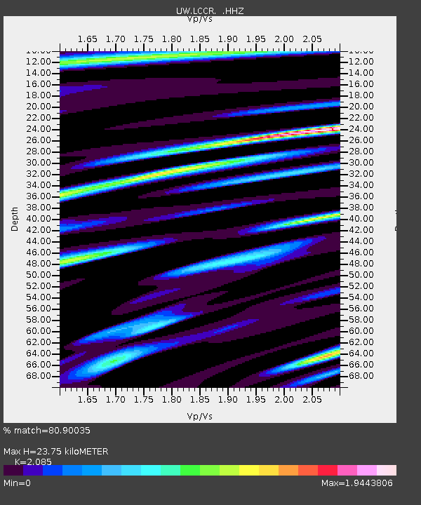
| Estimated Moho Depth: |
23.75 km |
| Estimated Crust Vp/Vs: |
2.09 |
| Assumed Crust Vp: |
6.566 km/s |
| Estimated Crust Vs: |
3.149 km/s |
| Estimated Crust Poisson's Ratio: |
0.35 |
|
| Radial Match: |
80.90035 % |
| Radial Bump: |
400 |
| Transverse Match: |
67.11793 % |
| Transverse Bump: |
400 |
| SOD ConfigId: |
790520 |
| Insert Time: |
2014-09-18 06:17:06.316 +0000 |
| GWidth: |
2.5 |
| Max Bumps: |
400 |
| Tol: |
0.001 |
|

Signal To Noise
| Channel | StoN | STA | LTA |
| UW:LCCR: :HHZ:20140904T05:45:28.377998Z | 6.269964 | 1.5025203E-6 | 2.3963776E-7 |
| UW:LCCR: :HHN:20140904T05:45:28.377998Z | 1.3472712 | 5.944635E-7 | 4.412352E-7 |
| UW:LCCR: :HHE:20140904T05:45:28.377998Z | 2.6055677 | 7.866946E-7 | 3.0192828E-7 |
| Arrivals |
| Ps | 4.0 SECOND |
| PpPs | 11 SECOND |
| PsPs/PpSs | 15 SECOND |


