You are here: Home > Network List > UW - Pacific Northwest Regional Seismic Network Stations List
> Station UMAT Pilot Rock, OR, USA > Earthquake Result Viewer
UMAT Pilot Rock, OR, USA - Earthquake Result Viewer
| Earthquake location: |
Tonga Islands |
| Earthquake latitude/longitude: |
-21.4/-173.3 |
| Earthquake time(UTC): |
2014/09/04 (247) 05:33:46 GMT |
| Earthquake Depth: |
12 km |
| Earthquake Magnitude: |
6.0 MWB |
| Earthquake Catalog/Contributor: |
NEIC PDE/NEIC COMCAT |
|
| Network: |
UW Pacific Northwest Regional Seismic Network |
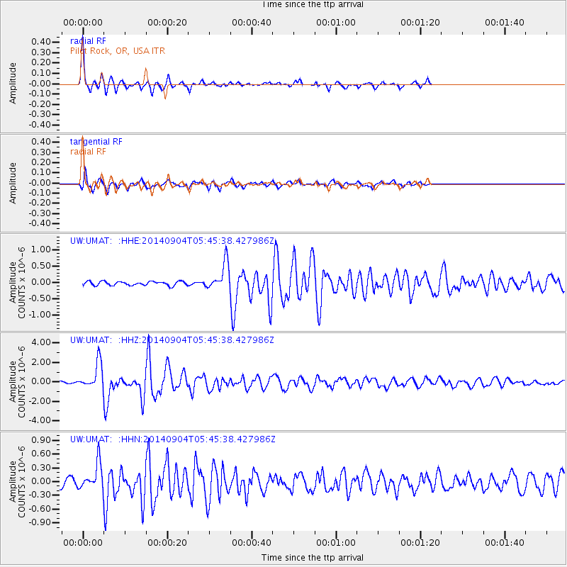
| Station: |
UMAT Pilot Rock, OR, USA |
| Lat/Lon: |
45.29 N/118.96 W |
| Elevation: |
1318 m |
|
| Distance: |
82.7 deg |
| Az: |
35.304 deg |
| Baz: |
229.724 deg |
| Ray Param: |
0.046698812 |
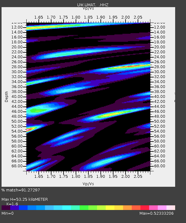
| Estimated Moho Depth: |
53.25 km |
| Estimated Crust Vp/Vs: |
1.60 |
| Assumed Crust Vp: |
6.571 km/s |
| Estimated Crust Vs: |
4.107 km/s |
| Estimated Crust Poisson's Ratio: |
0.18 |
|
| Radial Match: |
91.27297 % |
| Radial Bump: |
250 |
| Transverse Match: |
87.70126 % |
| Transverse Bump: |
346 |
| SOD ConfigId: |
790520 |
| Insert Time: |
2014-09-18 06:17:43.195 +0000 |
| GWidth: |
2.5 |
| Max Bumps: |
400 |
| Tol: |
0.001 |
|
Signal To Noise
| Channel | StoN | STA | LTA |
| UW:UMAT: :HHZ:20140904T05:45:38.427986Z | 16.149246 | 1.4140035E-6 | 8.7558476E-8 |
| UW:UMAT: :HHN:20140904T05:45:38.427986Z | 3.3547127 | 3.0475542E-7 | 9.084397E-8 |
| UW:UMAT: :HHE:20140904T05:45:38.427986Z | 7.0946774 | 4.3004655E-7 | 6.061538E-8 |
| Arrivals |
| Ps | 5.0 SECOND |
| PpPs | 20 SECOND |
| PsPs/PpSs | 25 SECOND |


