You are here: Home > Network List > WY - Yellowstone Wyoming Seismic Network Stations List
> Station YHH Holmes Hill, YNP, WY, USA > Earthquake Result Viewer
YHH Holmes Hill, YNP, WY, USA - Earthquake Result Viewer
| Earthquake location: |
Tonga Islands |
| Earthquake latitude/longitude: |
-21.4/-173.3 |
| Earthquake time(UTC): |
2014/09/04 (247) 05:33:46 GMT |
| Earthquake Depth: |
12 km |
| Earthquake Magnitude: |
6.0 MWB |
| Earthquake Catalog/Contributor: |
NEIC PDE/NEIC COMCAT |
|
| Network: |
WY Yellowstone Wyoming Seismic Network |
| Station: |
YHH Holmes Hill, YNP, WY, USA |
| Lat/Lon: |
44.79 N/110.85 W |
| Elevation: |
2717 m |
|
| Distance: |
87.0 deg |
| Az: |
39.195 deg |
| Baz: |
235.798 deg |
| Ray Param: |
0.04365396 |
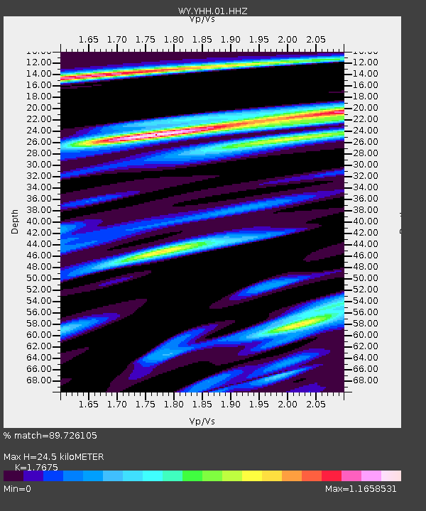
| Estimated Moho Depth: |
24.5 km |
| Estimated Crust Vp/Vs: |
1.77 |
| Assumed Crust Vp: |
6.35 km/s |
| Estimated Crust Vs: |
3.593 km/s |
| Estimated Crust Poisson's Ratio: |
0.26 |
|
| Radial Match: |
89.726105 % |
| Radial Bump: |
375 |
| Transverse Match: |
89.40654 % |
| Transverse Bump: |
386 |
| SOD ConfigId: |
790520 |
| Insert Time: |
2014-09-18 06:18:00.979 +0000 |
| GWidth: |
2.5 |
| Max Bumps: |
400 |
| Tol: |
0.001 |
|
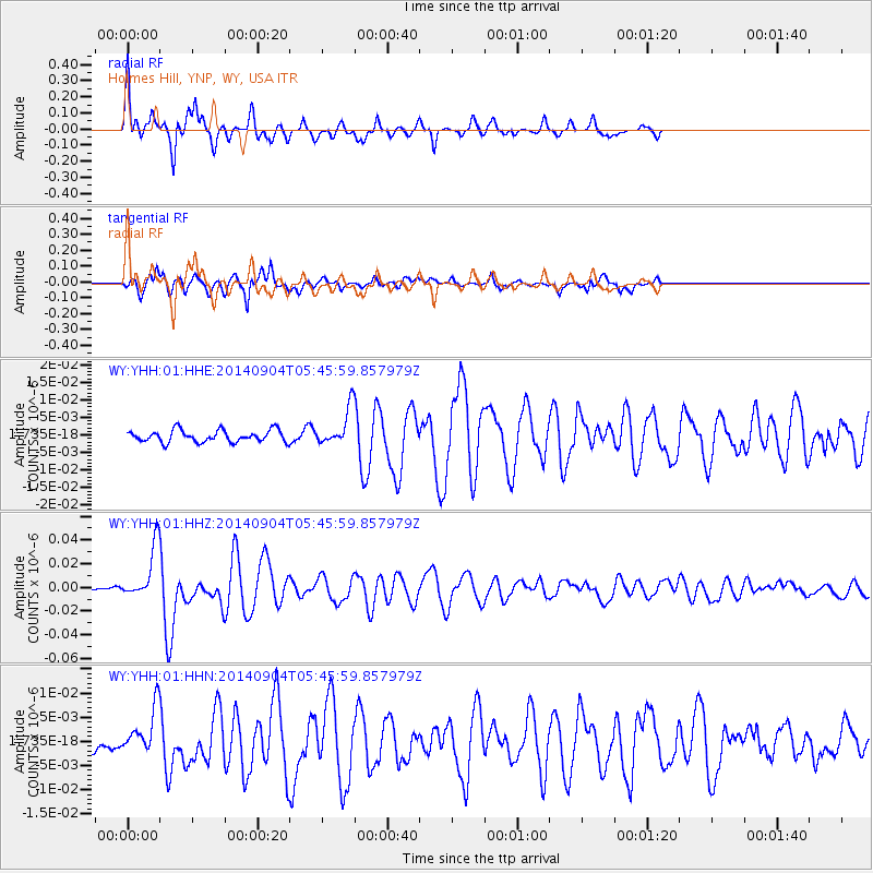
Signal To Noise
| Channel | StoN | STA | LTA |
| WY:YHH:01:HHZ:20140904T05:45:59.857979Z | 14.555188 | 2.186895E-8 | 1.5024848E-9 |
| WY:YHH:01:HHN:20140904T05:45:59.857979Z | 2.844744 | 4.4399457E-9 | 1.5607541E-9 |
| WY:YHH:01:HHE:20140904T05:45:59.857979Z | 3.035453 | 5.105144E-9 | 1.6818391E-9 |
| Arrivals |
| Ps | 3.0 SECOND |
| PpPs | 10 SECOND |
| PsPs/PpSs | 13 SECOND |


