You are here: Home > Network List > WY - Yellowstone Wyoming Seismic Network Stations List
> Station YMR Madison River, YNP, WY, USA > Earthquake Result Viewer
YMR Madison River, YNP, WY, USA - Earthquake Result Viewer
| Earthquake location: |
Tonga Islands |
| Earthquake latitude/longitude: |
-21.4/-173.3 |
| Earthquake time(UTC): |
2014/09/04 (247) 05:33:46 GMT |
| Earthquake Depth: |
12 km |
| Earthquake Magnitude: |
6.0 MWB |
| Earthquake Catalog/Contributor: |
NEIC PDE/NEIC COMCAT |
|
| Network: |
WY Yellowstone Wyoming Seismic Network |
| Station: |
YMR Madison River, YNP, WY, USA |
| Lat/Lon: |
44.67 N/110.96 W |
| Elevation: |
2149 m |
|
| Distance: |
86.8 deg |
| Az: |
39.248 deg |
| Baz: |
235.721 deg |
| Ray Param: |
0.043752745 |
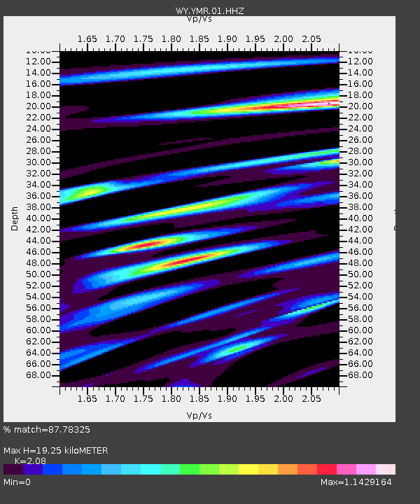
| Estimated Moho Depth: |
19.25 km |
| Estimated Crust Vp/Vs: |
2.08 |
| Assumed Crust Vp: |
6.35 km/s |
| Estimated Crust Vs: |
3.053 km/s |
| Estimated Crust Poisson's Ratio: |
0.35 |
|
| Radial Match: |
87.78325 % |
| Radial Bump: |
397 |
| Transverse Match: |
77.94359 % |
| Transverse Bump: |
400 |
| SOD ConfigId: |
790520 |
| Insert Time: |
2014-09-18 06:18:06.781 +0000 |
| GWidth: |
2.5 |
| Max Bumps: |
400 |
| Tol: |
0.001 |
|

Signal To Noise
| Channel | StoN | STA | LTA |
| WY:YMR:01:HHZ:20140904T05:45:59.208015Z | 11.159013 | 2.476675E-8 | 2.2194393E-9 |
| WY:YMR:01:HHN:20140904T05:45:59.208015Z | 1.2569594 | 5.5424825E-9 | 4.4094364E-9 |
| WY:YMR:01:HHE:20140904T05:45:59.208015Z | 1.6734203 | 7.481732E-9 | 4.4709223E-9 |
| Arrivals |
| Ps | 3.3 SECOND |
| PpPs | 9.2 SECOND |
| PsPs/PpSs | 12 SECOND |


