You are here: Home > Network List > PY - PFO Array Stations List
> Station BPH12 Pinon Flat Observatory, CA, USA > Earthquake Result Viewer
BPH12 Pinon Flat Observatory, CA, USA - Earthquake Result Viewer
| Earthquake location: |
Tonga Islands |
| Earthquake latitude/longitude: |
-21.4/-173.3 |
| Earthquake time(UTC): |
2014/09/04 (247) 05:33:46 GMT |
| Earthquake Depth: |
12 km |
| Earthquake Magnitude: |
6.0 MWB |
| Earthquake Catalog/Contributor: |
NEIC PDE/NEIC COMCAT |
|
| Network: |
PY PFO Array |
| Station: |
BPH12 Pinon Flat Observatory, CA, USA |
| Lat/Lon: |
33.61 N/116.46 W |
| Elevation: |
1251 m |
|
| Distance: |
76.9 deg |
| Az: |
45.798 deg |
| Baz: |
233.177 deg |
| Ray Param: |
0.050658017 |
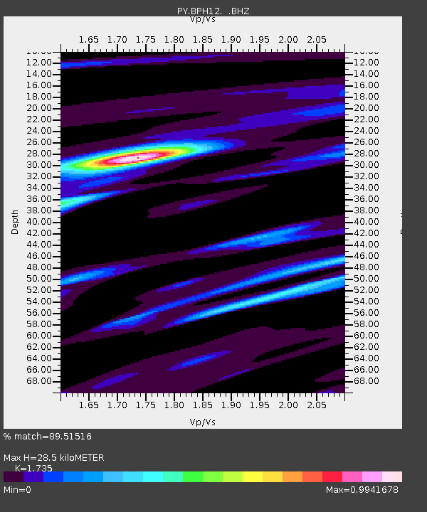
| Estimated Moho Depth: |
28.5 km |
| Estimated Crust Vp/Vs: |
1.74 |
| Assumed Crust Vp: |
6.264 km/s |
| Estimated Crust Vs: |
3.61 km/s |
| Estimated Crust Poisson's Ratio: |
0.25 |
|
| Radial Match: |
89.51516 % |
| Radial Bump: |
400 |
| Transverse Match: |
71.97247 % |
| Transverse Bump: |
400 |
| SOD ConfigId: |
790520 |
| Insert Time: |
2014-09-18 06:20:31.655 +0000 |
| GWidth: |
2.5 |
| Max Bumps: |
400 |
| Tol: |
0.001 |
|

Signal To Noise
| Channel | StoN | STA | LTA |
| PY:BPH12: :BHZ:20140904T05:45:07.274971Z | 18.632158 | 1.1447115E-6 | 6.143741E-8 |
| PY:BPH12: :BHN:20140904T05:45:07.274971Z | 6.1902986 | 2.89385E-7 | 4.6748152E-8 |
| PY:BPH12: :BHE:20140904T05:45:07.274971Z | 3.1696255 | 2.944515E-7 | 9.2897885E-8 |
| Arrivals |
| Ps | 3.4 SECOND |
| PpPs | 12 SECOND |
| PsPs/PpSs | 16 SECOND |


