You are here: Home > Network List > TA - USArray Transportable Network (new EarthScope stations) Stations List
> Station T54A Tazewell, VA, USA > Earthquake Result Viewer
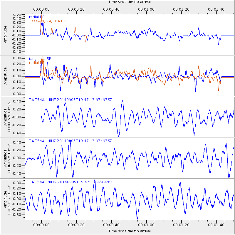
T54A Tazewell, VA, USA - Earthquake Result Viewer
*The percent match for this event was below the threshold and hence no stack was calculated.
| Earthquake location: |
Easter Island Region |
| Earthquake latitude/longitude: |
-26.7/-114.3 |
| Earthquake time(UTC): |
2014/09/05 (248) 19:36:32 GMT |
| Earthquake Depth: |
21 km |
| Earthquake Magnitude: |
5.8 MWW, 5.7 MWB, 5.8 MWC |
| Earthquake Catalog/Contributor: |
NEIC PDE/NEIC COMCAT |
|
| Network: |
TA USArray Transportable Network (new EarthScope stations) |
| Station: |
T54A Tazewell, VA, USA |
| Lat/Lon: |
37.06 N/81.58 W |
| Elevation: |
852 m |
|
| Distance: |
70.5 deg |
| Az: |
27.3 deg |
| Baz: |
210.851 deg |
| Ray Param: |
$rayparam |
*The percent match for this event was below the threshold and hence was not used in the summary stack. |
|
| Radial Match: |
45.224213 % |
| Radial Bump: |
400 |
| Transverse Match: |
44.067554 % |
| Transverse Bump: |
384 |
| SOD ConfigId: |
790520 |
| Insert Time: |
2014-09-19 20:04:21.210 +0000 |
| GWidth: |
2.5 |
| Max Bumps: |
400 |
| Tol: |
0.001 |
|
Signal To Noise
| Channel | StoN | STA | LTA |
| TA:T54A: :BHZ:20140905T19:47:13.974976Z | 1.1998782 | 1.6647886E-7 | 1.3874647E-7 |
| TA:T54A: :BHN:20140905T19:47:13.974976Z | 1.0182377 | 1.9207008E-7 | 1.8862991E-7 |
| TA:T54A: :BHE:20140905T19:47:13.974976Z | 0.8260311 | 1.320877E-7 | 1.5990645E-7 |
| Arrivals |
| Ps | |
| PpPs | |
| PsPs/PpSs | |


