You are here: Home > Network List > LD - Lamont-Doherty Cooperative Seismographic Network Stations List
> Station WUPA West Chester University of Pennsylvania > Earthquake Result Viewer
WUPA West Chester University of Pennsylvania - Earthquake Result Viewer
| Earthquake location: |
Easter Island Region |
| Earthquake latitude/longitude: |
-26.6/-114.5 |
| Earthquake time(UTC): |
2014/09/06 (249) 06:53:13 GMT |
| Earthquake Depth: |
10 km |
| Earthquake Magnitude: |
6.1 MB |
| Earthquake Catalog/Contributor: |
NEIC PDE/NEIC COMCAT |
|
| Network: |
LD Lamont-Doherty Cooperative Seismographic Network |
| Station: |
WUPA West Chester University of Pennsylvania |
| Lat/Lon: |
39.93 N/75.61 W |
| Elevation: |
86 m |
|
| Distance: |
75.5 deg |
| Az: |
29.887 deg |
| Baz: |
215.457 deg |
| Ray Param: |
0.051654078 |
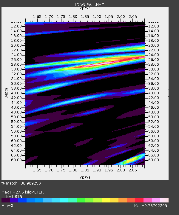
| Estimated Moho Depth: |
27.5 km |
| Estimated Crust Vp/Vs: |
1.91 |
| Assumed Crust Vp: |
6.287 km/s |
| Estimated Crust Vs: |
3.283 km/s |
| Estimated Crust Poisson's Ratio: |
0.31 |
|
| Radial Match: |
86.909256 % |
| Radial Bump: |
298 |
| Transverse Match: |
56.65988 % |
| Transverse Bump: |
400 |
| SOD ConfigId: |
790520 |
| Insert Time: |
2014-09-20 07:20:30.305 +0000 |
| GWidth: |
2.5 |
| Max Bumps: |
400 |
| Tol: |
0.001 |
|
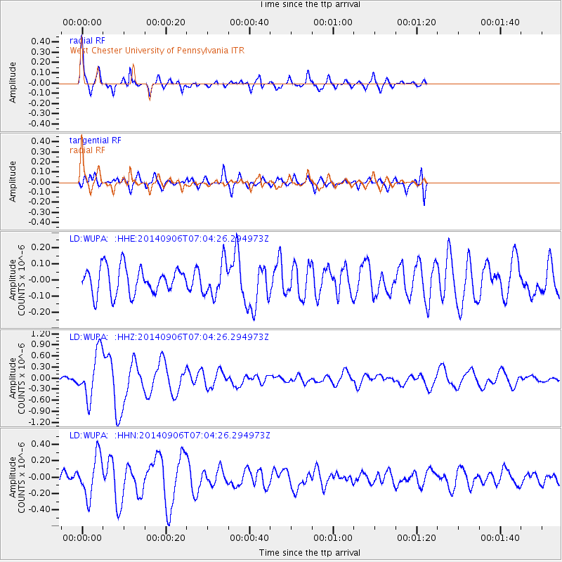
Signal To Noise
| Channel | StoN | STA | LTA |
| LD:WUPA: :HHZ:20140906T07:04:26.294973Z | 9.699151 | 6.4031826E-7 | 6.601797E-8 |
| LD:WUPA: :HHN:20140906T07:04:26.294973Z | 3.3802192 | 2.564864E-7 | 7.587863E-8 |
| LD:WUPA: :HHE:20140906T07:04:26.294973Z | 1.2655212 | 1.05622895E-7 | 8.346198E-8 |
| Arrivals |
| Ps | 4.1 SECOND |
| PpPs | 12 SECOND |
| PsPs/PpSs | 17 SECOND |


