You are here: Home > Network List > N4 - Central and EAstern US Network Stations List
> Station D41A Chassel, MI, USA > Earthquake Result Viewer
D41A Chassel, MI, USA - Earthquake Result Viewer
| Earthquake location: |
Easter Island Region |
| Earthquake latitude/longitude: |
-26.6/-114.5 |
| Earthquake time(UTC): |
2014/09/06 (249) 06:53:13 GMT |
| Earthquake Depth: |
10 km |
| Earthquake Magnitude: |
6.1 MB |
| Earthquake Catalog/Contributor: |
NEIC PDE/NEIC COMCAT |
|
| Network: |
N4 Central and EAstern US Network |
| Station: |
D41A Chassel, MI, USA |
| Lat/Lon: |
47.06 N/88.57 W |
| Elevation: |
271 m |
|
| Distance: |
77.0 deg |
| Az: |
17.843 deg |
| Baz: |
203.652 deg |
| Ray Param: |
0.0506291 |
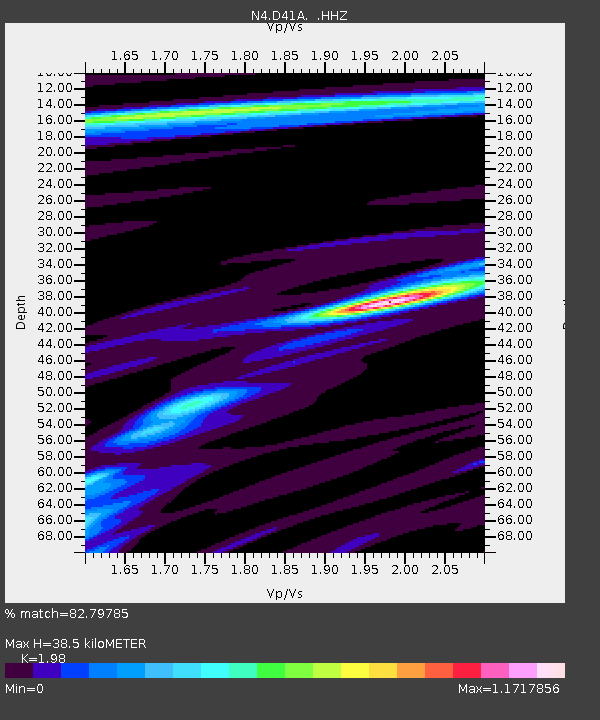
| Estimated Moho Depth: |
38.5 km |
| Estimated Crust Vp/Vs: |
1.98 |
| Assumed Crust Vp: |
6.467 km/s |
| Estimated Crust Vs: |
3.266 km/s |
| Estimated Crust Poisson's Ratio: |
0.33 |
|
| Radial Match: |
82.79785 % |
| Radial Bump: |
362 |
| Transverse Match: |
72.48922 % |
| Transverse Bump: |
400 |
| SOD ConfigId: |
790520 |
| Insert Time: |
2014-09-20 07:21:57.279 +0000 |
| GWidth: |
2.5 |
| Max Bumps: |
400 |
| Tol: |
0.001 |
|

Signal To Noise
| Channel | StoN | STA | LTA |
| N4:D41A: :HHZ:20140906T07:04:34.919973Z | 7.712157 | 2.0346547E-6 | 2.6382432E-7 |
| N4:D41A: :HHN:20140906T07:04:34.919973Z | 2.9703338 | 7.6873016E-7 | 2.588026E-7 |
| N4:D41A: :HHE:20140906T07:04:34.919973Z | 1.0697622 | 3.227997E-7 | 3.0174903E-7 |
| Arrivals |
| Ps | 6.0 SECOND |
| PpPs | 17 SECOND |
| PsPs/PpSs | 23 SECOND |


