You are here: Home > Network List > N4 - Central and EAstern US Network Stations List
> Station W52A Murphy, NC, USA > Earthquake Result Viewer
W52A Murphy, NC, USA - Earthquake Result Viewer
| Earthquake location: |
Easter Island Region |
| Earthquake latitude/longitude: |
-26.6/-114.5 |
| Earthquake time(UTC): |
2014/09/06 (249) 06:53:13 GMT |
| Earthquake Depth: |
10 km |
| Earthquake Magnitude: |
6.1 MB |
| Earthquake Catalog/Contributor: |
NEIC PDE/NEIC COMCAT |
|
| Network: |
N4 Central and EAstern US Network |
| Station: |
W52A Murphy, NC, USA |
| Lat/Lon: |
35.09 N/83.93 W |
| Elevation: |
519 m |
|
| Distance: |
67.8 deg |
| Az: |
26.729 deg |
| Baz: |
209.404 deg |
| Ray Param: |
0.056693677 |
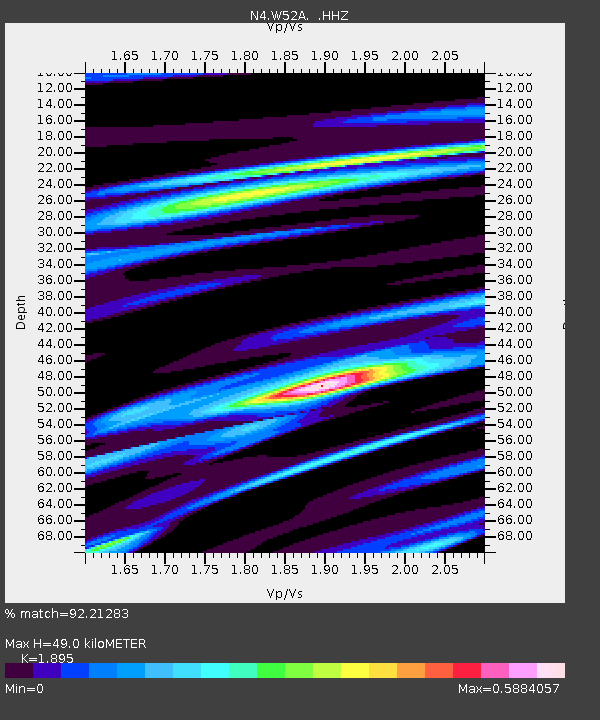
| Estimated Moho Depth: |
49.0 km |
| Estimated Crust Vp/Vs: |
1.89 |
| Assumed Crust Vp: |
6.35 km/s |
| Estimated Crust Vs: |
3.351 km/s |
| Estimated Crust Poisson's Ratio: |
0.31 |
|
| Radial Match: |
92.21283 % |
| Radial Bump: |
202 |
| Transverse Match: |
66.787544 % |
| Transverse Bump: |
400 |
| SOD ConfigId: |
790520 |
| Insert Time: |
2014-09-20 07:23:53.914 +0000 |
| GWidth: |
2.5 |
| Max Bumps: |
400 |
| Tol: |
0.001 |
|

Signal To Noise
| Channel | StoN | STA | LTA |
| N4:W52A: :HHZ:20140906T07:03:40.549978Z | 13.725005 | 1.68624E-6 | 1.2285896E-7 |
| N4:W52A: :HHN:20140906T07:03:40.549978Z | 6.6181684 | 5.6254925E-7 | 8.500074E-8 |
| N4:W52A: :HHE:20140906T07:03:40.549978Z | 4.458415 | 4.7236432E-7 | 1.0594893E-7 |
| Arrivals |
| Ps | 7.2 SECOND |
| PpPs | 22 SECOND |
| PsPs/PpSs | 29 SECOND |


