You are here: Home > Network List > NE - New England Seismic Network Stations List
> Station FFD Franklin Falls Dam, NH, USA > Earthquake Result Viewer
FFD Franklin Falls Dam, NH, USA - Earthquake Result Viewer
| Earthquake location: |
Easter Island Region |
| Earthquake latitude/longitude: |
-26.6/-114.5 |
| Earthquake time(UTC): |
2014/09/06 (249) 06:53:13 GMT |
| Earthquake Depth: |
10 km |
| Earthquake Magnitude: |
6.1 MB |
| Earthquake Catalog/Contributor: |
NEIC PDE/NEIC COMCAT |
|
| Network: |
NE New England Seismic Network |
| Station: |
FFD Franklin Falls Dam, NH, USA |
| Lat/Lon: |
43.47 N/71.65 W |
| Elevation: |
131 m |
|
| Distance: |
80.1 deg |
| Az: |
30.147 deg |
| Baz: |
218.134 deg |
| Ray Param: |
0.04853323 |
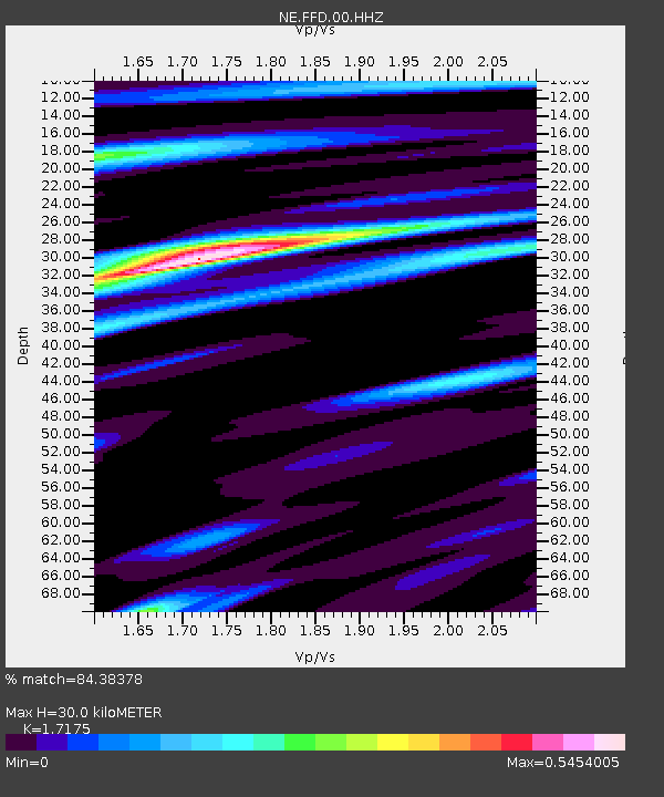
| Estimated Moho Depth: |
30.0 km |
| Estimated Crust Vp/Vs: |
1.72 |
| Assumed Crust Vp: |
6.419 km/s |
| Estimated Crust Vs: |
3.738 km/s |
| Estimated Crust Poisson's Ratio: |
0.24 |
|
| Radial Match: |
84.38378 % |
| Radial Bump: |
369 |
| Transverse Match: |
77.059784 % |
| Transverse Bump: |
400 |
| SOD ConfigId: |
790520 |
| Insert Time: |
2014-09-20 07:25:32.481 +0000 |
| GWidth: |
2.5 |
| Max Bumps: |
400 |
| Tol: |
0.001 |
|

Signal To Noise
| Channel | StoN | STA | LTA |
| NE:FFD:00:HHZ:20140906T07:04:51.854971Z | 8.556823 | 1.6997351E-6 | 1.9864092E-7 |
| NE:FFD:00:HH1:20140906T07:04:51.854971Z | 3.2994893 | 5.493109E-7 | 1.6648363E-7 |
| NE:FFD:00:HH2:20140906T07:04:51.854971Z | 1.9983811 | 3.6053862E-7 | 1.8041534E-7 |
| Arrivals |
| Ps | 3.5 SECOND |
| PpPs | 12 SECOND |
| PsPs/PpSs | 16 SECOND |


