You are here: Home > Network List > NM - Cooperative New Madrid Seismic Network Stations List
> Station UTMT Martin, TN > Earthquake Result Viewer
UTMT Martin, TN - Earthquake Result Viewer
| Earthquake location: |
Easter Island Region |
| Earthquake latitude/longitude: |
-26.6/-114.5 |
| Earthquake time(UTC): |
2014/09/06 (249) 06:53:13 GMT |
| Earthquake Depth: |
10 km |
| Earthquake Magnitude: |
6.1 MB |
| Earthquake Catalog/Contributor: |
NEIC PDE/NEIC COMCAT |
|
| Network: |
NM Cooperative New Madrid Seismic Network |
| Station: |
UTMT Martin, TN |
| Lat/Lon: |
36.35 N/88.86 W |
| Elevation: |
110 m |
|
| Distance: |
67.1 deg |
| Az: |
22.241 deg |
| Baz: |
204.815 deg |
| Ray Param: |
0.057160072 |
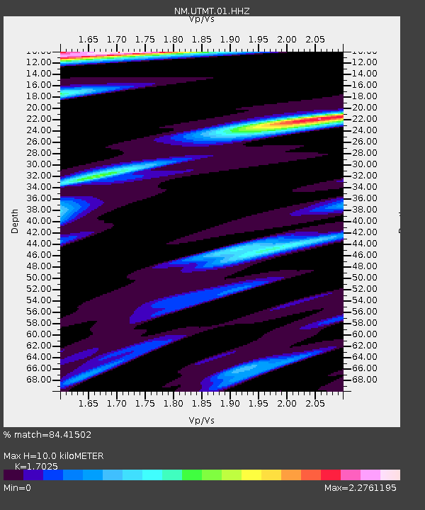
| Estimated Moho Depth: |
10.0 km |
| Estimated Crust Vp/Vs: |
1.70 |
| Assumed Crust Vp: |
6.444 km/s |
| Estimated Crust Vs: |
3.785 km/s |
| Estimated Crust Poisson's Ratio: |
0.24 |
|
| Radial Match: |
84.41502 % |
| Radial Bump: |
336 |
| Transverse Match: |
68.02159 % |
| Transverse Bump: |
322 |
| SOD ConfigId: |
790520 |
| Insert Time: |
2014-09-20 07:27:02.109 +0000 |
| GWidth: |
2.5 |
| Max Bumps: |
400 |
| Tol: |
0.001 |
|
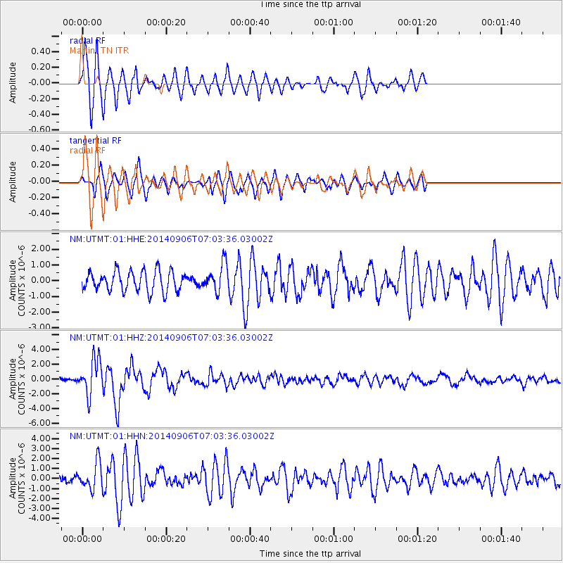
Signal To Noise
| Channel | StoN | STA | LTA |
| NM:UTMT:01:HHZ:20140906T07:03:36.03002Z | 9.854531 | 2.4425435E-6 | 2.4785993E-7 |
| NM:UTMT:01:HHN:20140906T07:03:36.03002Z | 3.530876 | 1.3640658E-6 | 3.8632504E-7 |
| NM:UTMT:01:HHE:20140906T07:03:36.03002Z | 1.3971922 | 8.920947E-7 | 6.38491E-7 |
| Arrivals |
| Ps | 1.1 SECOND |
| PpPs | 4.0 SECOND |
| PsPs/PpSs | 5.2 SECOND |


