You are here: Home > Network List > OK - Oklahoma Seismic Network Stations List
> Station QUOK Quay, Oklahoma > Earthquake Result Viewer
QUOK Quay, Oklahoma - Earthquake Result Viewer
| Earthquake location: |
Easter Island Region |
| Earthquake latitude/longitude: |
-26.6/-114.5 |
| Earthquake time(UTC): |
2014/09/06 (249) 06:53:13 GMT |
| Earthquake Depth: |
10 km |
| Earthquake Magnitude: |
6.1 MB |
| Earthquake Catalog/Contributor: |
NEIC PDE/NEIC COMCAT |
|
| Network: |
OK Oklahoma Seismic Network |
| Station: |
QUOK Quay, Oklahoma |
| Lat/Lon: |
36.17 N/96.71 W |
| Elevation: |
296 m |
|
| Distance: |
64.7 deg |
| Az: |
15.837 deg |
| Baz: |
197.572 deg |
| Ray Param: |
0.05877612 |
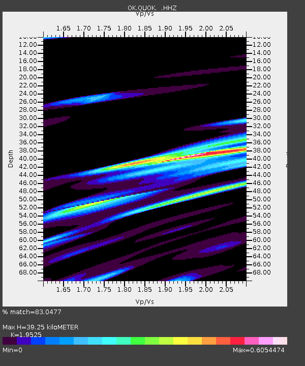
| Estimated Moho Depth: |
39.25 km |
| Estimated Crust Vp/Vs: |
1.95 |
| Assumed Crust Vp: |
6.483 km/s |
| Estimated Crust Vs: |
3.32 km/s |
| Estimated Crust Poisson's Ratio: |
0.32 |
|
| Radial Match: |
83.0477 % |
| Radial Bump: |
357 |
| Transverse Match: |
67.56618 % |
| Transverse Bump: |
400 |
| SOD ConfigId: |
790520 |
| Insert Time: |
2014-09-20 07:28:38.278 +0000 |
| GWidth: |
2.5 |
| Max Bumps: |
400 |
| Tol: |
0.001 |
|

Signal To Noise
| Channel | StoN | STA | LTA |
| OK:QUOK: :HHZ:20140906T07:03:20.228994Z | 4.7620654 | 1.7479359E-6 | 3.6705416E-7 |
| OK:QUOK: :HHN:20140906T07:03:20.228994Z | 3.9914436 | 1.0618911E-6 | 2.660419E-7 |
| OK:QUOK: :HHE:20140906T07:03:20.228994Z | 1.2569222 | 3.0305787E-7 | 2.4111108E-7 |
| Arrivals |
| Ps | 6.0 SECOND |
| PpPs | 17 SECOND |
| PsPs/PpSs | 23 SECOND |


