You are here: Home > Network List > PE - Penn State Network Stations List
> Station PAGS PA Geological Survey > Earthquake Result Viewer
PAGS PA Geological Survey - Earthquake Result Viewer

| Earthquake location: |
Easter Island Region |
| Earthquake latitude/longitude: |
-26.6/-114.5 |
| Earthquake time(UTC): |
2014/09/06 (249) 06:53:13 GMT |
| Earthquake Depth: |
10 km |
| Earthquake Magnitude: |
6.1 MB |
| Earthquake Catalog/Contributor: |
NEIC PDE/NEIC COMCAT |
|
| Network: |
PE Penn State Network |
| Station: |
PAGS PA Geological Survey |
| Lat/Lon: |
40.23 N/76.72 W |
| Elevation: |
120 m |
|
| Distance: |
75.2 deg |
| Az: |
28.987 deg |
| Baz: |
214.514 deg |
| Ray Param: |
0.051820535 |
| Estimated Moho Depth: |
14.25 km |
| Estimated Crust Vp/Vs: |
2.00 |
| Assumed Crust Vp: |
6.121 km/s |
| Estimated Crust Vs: |
3.06 km/s |
| Estimated Crust Poisson's Ratio: |
0.33 |
|
| Radial Match: |
90.397865 % |
| Radial Bump: |
387 |
| Transverse Match: |
76.75122 % |
| Transverse Bump: |
400 |
| SOD ConfigId: |
790520 |
| Insert Time: |
2014-09-20 07:34:48.319 +0000 |
| GWidth: |
2.5 |
| Max Bumps: |
400 |
| Tol: |
0.001 |
|
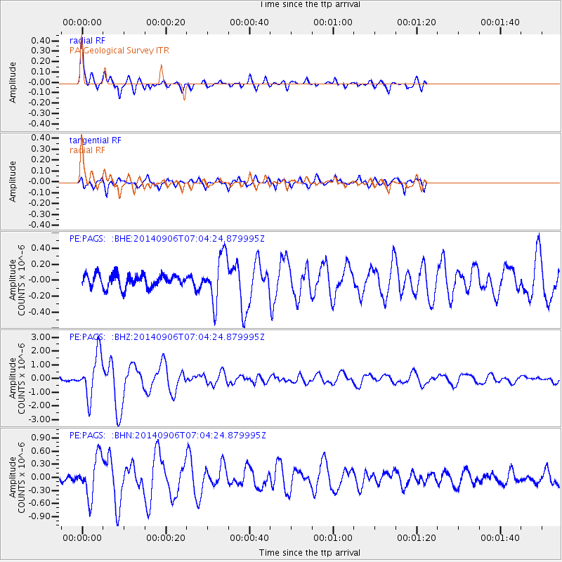
Signal To Noise
| Channel | StoN | STA | LTA |
| PE:PAGS: :BHZ:20140906T07:04:24.879995Z | 12.869625 | 1.6192122E-6 | 1.2581657E-7 |
| PE:PAGS: :BHN:20140906T07:04:24.879995Z | 4.041488 | 4.758169E-7 | 1.177331E-7 |
| PE:PAGS: :BHE:20140906T07:04:24.879995Z | 3.7464747 | 3.0040755E-7 | 8.018406E-8 |
| Arrivals |
| Ps | 2.4 SECOND |
| PpPs | 6.8 SECOND |
| PsPs/PpSs | 9.2 SECOND |


