You are here: Home > Network List > PR - Puerto Rico Seismic Network (PRSN) & Puerto Rico Strong Motion Program (PRSMP) Stations List
> Station CUPR Culebra > Earthquake Result Viewer
CUPR Culebra - Earthquake Result Viewer
| Earthquake location: |
Easter Island Region |
| Earthquake latitude/longitude: |
-26.6/-114.5 |
| Earthquake time(UTC): |
2014/09/06 (249) 06:53:13 GMT |
| Earthquake Depth: |
10 km |
| Earthquake Magnitude: |
6.1 MB |
| Earthquake Catalog/Contributor: |
NEIC PDE/NEIC COMCAT |
|
| Network: |
PR Puerto Rico Seismic Network (PRSN) & Puerto Rico Strong Motion Program (PRSMP) |
| Station: |
CUPR Culebra |
| Lat/Lon: |
18.31 N/65.28 W |
| Elevation: |
7.0 m |
|
| Distance: |
65.4 deg |
| Az: |
52.263 deg |
| Baz: |
228.174 deg |
| Ray Param: |
0.05831822 |
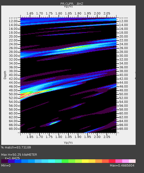
| Estimated Moho Depth: |
50.25 km |
| Estimated Crust Vp/Vs: |
1.64 |
| Assumed Crust Vp: |
5.14 km/s |
| Estimated Crust Vs: |
3.129 km/s |
| Estimated Crust Poisson's Ratio: |
0.21 |
|
| Radial Match: |
83.73189 % |
| Radial Bump: |
400 |
| Transverse Match: |
80.08247 % |
| Transverse Bump: |
400 |
| SOD ConfigId: |
790520 |
| Insert Time: |
2014-09-20 07:36:14.732 +0000 |
| GWidth: |
2.5 |
| Max Bumps: |
400 |
| Tol: |
0.001 |
|

Signal To Noise
| Channel | StoN | STA | LTA |
| PR:CUPR: :BHZ:20140906T07:03:24.799978Z | 8.649215 | 1.5903579E-6 | 1.8387311E-7 |
| PR:CUPR: :BHN:20140906T07:03:24.799978Z | 1.4237158 | 2.553226E-7 | 1.7933536E-7 |
| PR:CUPR: :BHE:20140906T07:03:24.799978Z | 2.829875 | 6.146874E-7 | 2.1721362E-7 |
| Arrivals |
| Ps | 6.5 SECOND |
| PpPs | 25 SECOND |
| PsPs/PpSs | 32 SECOND |


