You are here: Home > Network List > TA - USArray Transportable Network (new EarthScope stations) Stations List
> Station D53A Lac Vacive, Pontiac, Mrc, QC, CAN > Earthquake Result Viewer
D53A Lac Vacive, Pontiac, Mrc, QC, CAN - Earthquake Result Viewer
| Earthquake location: |
Easter Island Region |
| Earthquake latitude/longitude: |
-26.6/-114.5 |
| Earthquake time(UTC): |
2014/09/06 (249) 06:53:13 GMT |
| Earthquake Depth: |
10 km |
| Earthquake Magnitude: |
6.1 MB |
| Earthquake Catalog/Contributor: |
NEIC PDE/NEIC COMCAT |
|
| Network: |
TA USArray Transportable Network (new EarthScope stations) |
| Station: |
D53A Lac Vacive, Pontiac, Mrc, QC, CAN |
| Lat/Lon: |
47.08 N/77.70 W |
| Elevation: |
347 m |
|
| Distance: |
80.5 deg |
| Az: |
24.496 deg |
| Baz: |
212.894 deg |
| Ray Param: |
0.048221935 |
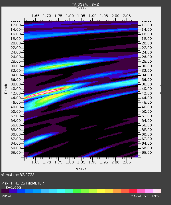
| Estimated Moho Depth: |
41.25 km |
| Estimated Crust Vp/Vs: |
1.70 |
| Assumed Crust Vp: |
6.622 km/s |
| Estimated Crust Vs: |
3.907 km/s |
| Estimated Crust Poisson's Ratio: |
0.23 |
|
| Radial Match: |
82.0733 % |
| Radial Bump: |
400 |
| Transverse Match: |
65.75246 % |
| Transverse Bump: |
400 |
| SOD ConfigId: |
790520 |
| Insert Time: |
2014-09-20 07:39:18.374 +0000 |
| GWidth: |
2.5 |
| Max Bumps: |
400 |
| Tol: |
0.001 |
|

Signal To Noise
| Channel | StoN | STA | LTA |
| TA:D53A: :BHZ:20140906T07:04:54.299978Z | 9.502318 | 1.8446656E-6 | 1.9412795E-7 |
| TA:D53A: :BHN:20140906T07:04:54.299978Z | 3.883399 | 4.3948944E-7 | 1.1317133E-7 |
| TA:D53A: :BHE:20140906T07:04:54.299978Z | 2.7113488 | 3.981204E-7 | 1.4683481E-7 |
| Arrivals |
| Ps | 4.5 SECOND |
| PpPs | 16 SECOND |
| PsPs/PpSs | 21 SECOND |


