You are here: Home > Network List > TA - USArray Transportable Network (new EarthScope stations) Stations List
> Station E54A Lac Daplat, Pontiac, MRC, QC, CAN > Earthquake Result Viewer
E54A Lac Daplat, Pontiac, MRC, QC, CAN - Earthquake Result Viewer
| Earthquake location: |
Easter Island Region |
| Earthquake latitude/longitude: |
-26.6/-114.5 |
| Earthquake time(UTC): |
2014/09/06 (249) 06:53:13 GMT |
| Earthquake Depth: |
10 km |
| Earthquake Magnitude: |
6.1 MB |
| Earthquake Catalog/Contributor: |
NEIC PDE/NEIC COMCAT |
|
| Network: |
TA USArray Transportable Network (new EarthScope stations) |
| Station: |
E54A Lac Daplat, Pontiac, MRC, QC, CAN |
| Lat/Lon: |
46.43 N/77.19 W |
| Elevation: |
277 m |
|
| Distance: |
80.2 deg |
| Az: |
25.154 deg |
| Baz: |
213.377 deg |
| Ray Param: |
0.048459888 |
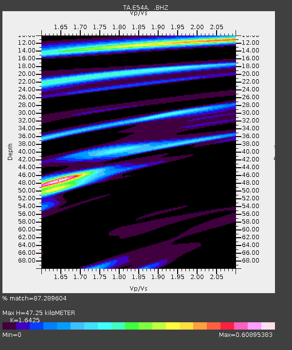
| Estimated Moho Depth: |
47.25 km |
| Estimated Crust Vp/Vs: |
1.64 |
| Assumed Crust Vp: |
6.622 km/s |
| Estimated Crust Vs: |
4.032 km/s |
| Estimated Crust Poisson's Ratio: |
0.21 |
|
| Radial Match: |
87.289604 % |
| Radial Bump: |
400 |
| Transverse Match: |
75.66785 % |
| Transverse Bump: |
400 |
| SOD ConfigId: |
790520 |
| Insert Time: |
2014-09-20 07:40:00.533 +0000 |
| GWidth: |
2.5 |
| Max Bumps: |
400 |
| Tol: |
0.001 |
|
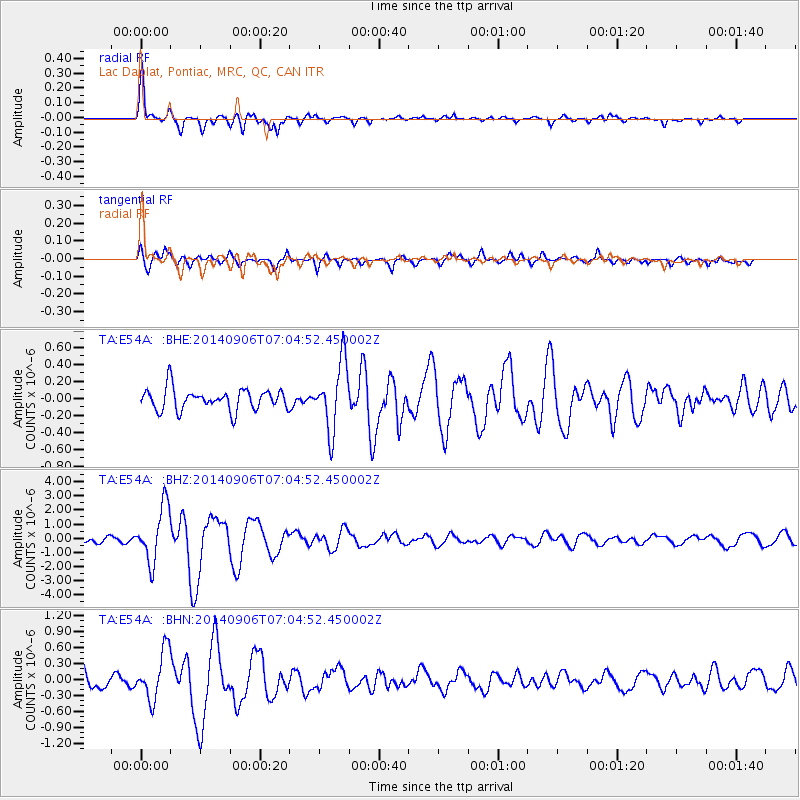
Signal To Noise
| Channel | StoN | STA | LTA |
| TA:E54A: :BHZ:20140906T07:04:52.450002Z | 7.6549006 | 1.9603574E-6 | 2.5609182E-7 |
| TA:E54A: :BHN:20140906T07:04:52.450002Z | 2.2380748 | 4.583629E-7 | 2.048023E-7 |
| TA:E54A: :BHE:20140906T07:04:52.450002Z | 3.1770155 | 3.982415E-7 | 1.2535081E-7 |
| Arrivals |
| Ps | 4.7 SECOND |
| PpPs | 18 SECOND |
| PsPs/PpSs | 23 SECOND |


