You are here: Home > Network List > TA - USArray Transportable Network (new EarthScope stations) Stations List
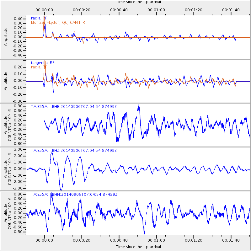
> Station E55A Montcerf-Lytton, QC, CAN > Earthquake Result Viewer
E55A Montcerf-Lytton, QC, CAN - Earthquake Result Viewer
| Earthquake location: |
Easter Island Region |
| Earthquake latitude/longitude: |
-26.6/-114.5 |
| Earthquake time(UTC): |
2014/09/06 (249) 06:53:13 GMT |
| Earthquake Depth: |
10 km |
| Earthquake Magnitude: |
6.1 MB |
| Earthquake Catalog/Contributor: |
NEIC PDE/NEIC COMCAT |
|
| Network: |
TA USArray Transportable Network (new EarthScope stations) |
| Station: |
E55A Montcerf-Lytton, QC, CAN |
| Lat/Lon: |
46.45 N/76.06 W |
| Elevation: |
180 m |
|
| Distance: |
80.6 deg |
| Az: |
25.801 deg |
| Baz: |
214.301 deg |
| Ray Param: |
0.048151743 |
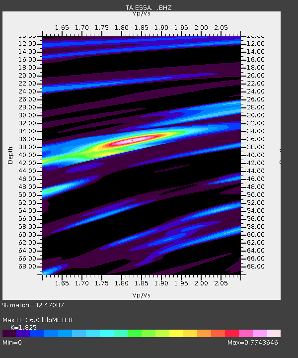
| Estimated Moho Depth: |
36.0 km |
| Estimated Crust Vp/Vs: |
1.83 |
| Assumed Crust Vp: |
6.622 km/s |
| Estimated Crust Vs: |
3.629 km/s |
| Estimated Crust Poisson's Ratio: |
0.29 |
|
| Radial Match: |
82.47087 % |
| Radial Bump: |
400 |
| Transverse Match: |
69.571045 % |
| Transverse Bump: |
400 |
| SOD ConfigId: |
790520 |
| Insert Time: |
2014-09-20 07:40:03.955 +0000 |
| GWidth: |
2.5 |
| Max Bumps: |
400 |
| Tol: |
0.001 |
|
Signal To Noise
| Channel | StoN | STA | LTA |
| TA:E55A: :BHZ:20140906T07:04:54.87499Z | 7.6901655 | 1.4593794E-6 | 1.8977217E-7 |
| TA:E55A: :BHN:20140906T07:04:54.87499Z | 3.4802377 | 4.6487864E-7 | 1.3357669E-7 |
| TA:E55A: :BHE:20140906T07:04:54.87499Z | 1.4034759 | 2.7015807E-7 | 1.9249212E-7 |
| Arrivals |
| Ps | 4.6 SECOND |
| PpPs | 15 SECOND |
| PsPs/PpSs | 20 SECOND |


