You are here: Home > Network List > TA - USArray Transportable Network (new EarthScope stations) Stations List
> Station E62A Clayton Lake, ME, USA > Earthquake Result Viewer
E62A Clayton Lake, ME, USA - Earthquake Result Viewer
| Earthquake location: |
Easter Island Region |
| Earthquake latitude/longitude: |
-26.6/-114.5 |
| Earthquake time(UTC): |
2014/09/06 (249) 06:53:13 GMT |
| Earthquake Depth: |
10 km |
| Earthquake Magnitude: |
6.1 MB |
| Earthquake Catalog/Contributor: |
NEIC PDE/NEIC COMCAT |
|
| Network: |
TA USArray Transportable Network (new EarthScope stations) |
| Station: |
E62A Clayton Lake, ME, USA |
| Lat/Lon: |
46.62 N/69.52 W |
| Elevation: |
356 m |
|
| Distance: |
83.5 deg |
| Az: |
29.341 deg |
| Baz: |
219.522 deg |
| Ray Param: |
0.046170335 |
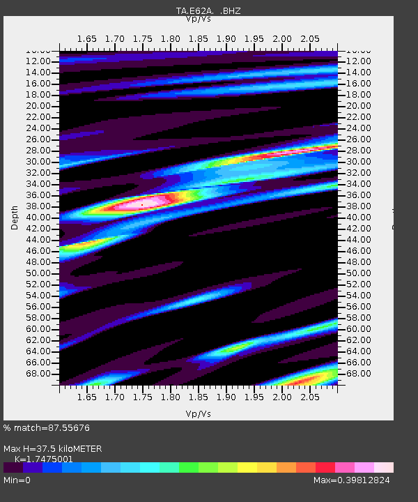
| Estimated Moho Depth: |
37.5 km |
| Estimated Crust Vp/Vs: |
1.75 |
| Assumed Crust Vp: |
6.419 km/s |
| Estimated Crust Vs: |
3.673 km/s |
| Estimated Crust Poisson's Ratio: |
0.26 |
|
| Radial Match: |
87.55676 % |
| Radial Bump: |
400 |
| Transverse Match: |
77.083115 % |
| Transverse Bump: |
400 |
| SOD ConfigId: |
790520 |
| Insert Time: |
2014-09-20 07:40:20.896 +0000 |
| GWidth: |
2.5 |
| Max Bumps: |
400 |
| Tol: |
0.001 |
|
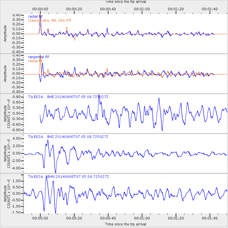
Signal To Noise
| Channel | StoN | STA | LTA |
| TA:E62A: :BHZ:20140906T07:05:09.725027Z | 8.200872 | 2.0254975E-6 | 2.469856E-7 |
| TA:E62A: :BHN:20140906T07:05:09.725027Z | 4.1019773 | 7.317688E-7 | 1.7839416E-7 |
| TA:E62A: :BHE:20140906T07:05:09.725027Z | 1.7853582 | 3.8152143E-7 | 2.136946E-7 |
| Arrivals |
| Ps | 4.5 SECOND |
| PpPs | 16 SECOND |
| PsPs/PpSs | 20 SECOND |


