You are here: Home > Network List > TA - USArray Transportable Network (new EarthScope stations) Stations List
> Station F04D Rainier, OR, USA > Earthquake Result Viewer
F04D Rainier, OR, USA - Earthquake Result Viewer
| Earthquake location: |
Easter Island Region |
| Earthquake latitude/longitude: |
-26.6/-114.5 |
| Earthquake time(UTC): |
2014/09/06 (249) 06:53:13 GMT |
| Earthquake Depth: |
10 km |
| Earthquake Magnitude: |
6.1 MB |
| Earthquake Catalog/Contributor: |
NEIC PDE/NEIC COMCAT |
|
| Network: |
TA USArray Transportable Network (new EarthScope stations) |
| Station: |
F04D Rainier, OR, USA |
| Lat/Lon: |
46.08 N/123.01 W |
| Elevation: |
236 m |
|
| Distance: |
72.8 deg |
| Az: |
353.777 deg |
| Baz: |
171.986 deg |
| Ray Param: |
0.05343686 |
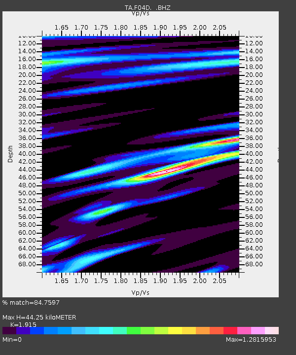
| Estimated Moho Depth: |
44.25 km |
| Estimated Crust Vp/Vs: |
1.91 |
| Assumed Crust Vp: |
6.566 km/s |
| Estimated Crust Vs: |
3.429 km/s |
| Estimated Crust Poisson's Ratio: |
0.31 |
|
| Radial Match: |
84.7597 % |
| Radial Bump: |
399 |
| Transverse Match: |
82.205574 % |
| Transverse Bump: |
356 |
| SOD ConfigId: |
790520 |
| Insert Time: |
2014-09-20 07:40:32.796 +0000 |
| GWidth: |
2.5 |
| Max Bumps: |
400 |
| Tol: |
0.001 |
|

Signal To Noise
| Channel | StoN | STA | LTA |
| TA:F04D: :BHZ:20140906T07:04:10.674978Z | 8.768833 | 2.2032389E-6 | 2.5125792E-7 |
| TA:F04D: :BHN:20140906T07:04:10.674978Z | 2.486392 | 8.065747E-7 | 3.2439561E-7 |
| TA:F04D: :BHE:20140906T07:04:10.674978Z | 0.9172247 | 3.199142E-7 | 3.4878497E-7 |
| Arrivals |
| Ps | 6.4 SECOND |
| PpPs | 19 SECOND |
| PsPs/PpSs | 25 SECOND |


