You are here: Home > Network List > TA - USArray Transportable Network (new EarthScope stations) Stations List
> Station F62A Pittston Farm, Pittston Academy Grant, ME, USA > Earthquake Result Viewer
F62A Pittston Farm, Pittston Academy Grant, ME, USA - Earthquake Result Viewer

| Earthquake location: |
Easter Island Region |
| Earthquake latitude/longitude: |
-26.6/-114.5 |
| Earthquake time(UTC): |
2014/09/06 (249) 06:53:13 GMT |
| Earthquake Depth: |
10 km |
| Earthquake Magnitude: |
6.1 MB |
| Earthquake Catalog/Contributor: |
NEIC PDE/NEIC COMCAT |
|
| Network: |
TA USArray Transportable Network (new EarthScope stations) |
| Station: |
F62A Pittston Farm, Pittston Academy Grant, ME, USA |
| Lat/Lon: |
45.90 N/69.97 W |
| Elevation: |
331 m |
|
| Distance: |
82.7 deg |
| Az: |
29.563 deg |
| Baz: |
219.229 deg |
| Ray Param: |
0.046699237 |
| Estimated Moho Depth: |
37.5 km |
| Estimated Crust Vp/Vs: |
1.84 |
| Assumed Crust Vp: |
6.419 km/s |
| Estimated Crust Vs: |
3.493 km/s |
| Estimated Crust Poisson's Ratio: |
0.29 |
|
| Radial Match: |
89.50049 % |
| Radial Bump: |
392 |
| Transverse Match: |
60.19912 % |
| Transverse Bump: |
400 |
| SOD ConfigId: |
790520 |
| Insert Time: |
2014-09-20 07:40:51.384 +0000 |
| GWidth: |
2.5 |
| Max Bumps: |
400 |
| Tol: |
0.001 |
|
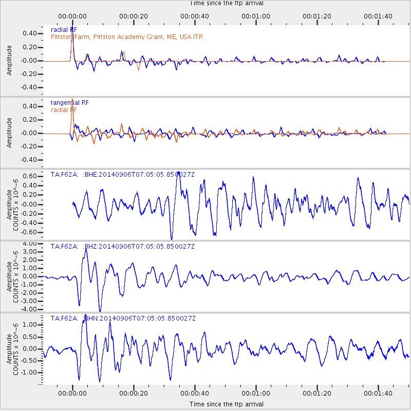
Signal To Noise
| Channel | StoN | STA | LTA |
| TA:F62A: :BHZ:20140906T07:05:05.850027Z | 14.414076 | 1.9382946E-6 | 1.3447236E-7 |
| TA:F62A: :BHN:20140906T07:05:05.850027Z | 6.292337 | 7.7969895E-7 | 1.2391246E-7 |
| TA:F62A: :BHE:20140906T07:05:05.850027Z | 2.4887462 | 3.9091483E-7 | 1.57073E-7 |
| Arrivals |
| Ps | 5.0 SECOND |
| PpPs | 16 SECOND |
| PsPs/PpSs | 21 SECOND |


