You are here: Home > Network List > TA - USArray Transportable Network (new EarthScope stations) Stations List
> Station G54A Lake Saint Peter, ON, CAN > Earthquake Result Viewer
G54A Lake Saint Peter, ON, CAN - Earthquake Result Viewer
| Earthquake location: |
Easter Island Region |
| Earthquake latitude/longitude: |
-26.6/-114.5 |
| Earthquake time(UTC): |
2014/09/06 (249) 06:53:13 GMT |
| Earthquake Depth: |
10 km |
| Earthquake Magnitude: |
6.1 MB |
| Earthquake Catalog/Contributor: |
NEIC PDE/NEIC COMCAT |
|
| Network: |
TA USArray Transportable Network (new EarthScope stations) |
| Station: |
G54A Lake Saint Peter, ON, CAN |
| Lat/Lon: |
45.40 N/78.09 W |
| Elevation: |
465 m |
|
| Distance: |
79.0 deg |
| Az: |
25.192 deg |
| Baz: |
212.737 deg |
| Ray Param: |
0.049289603 |
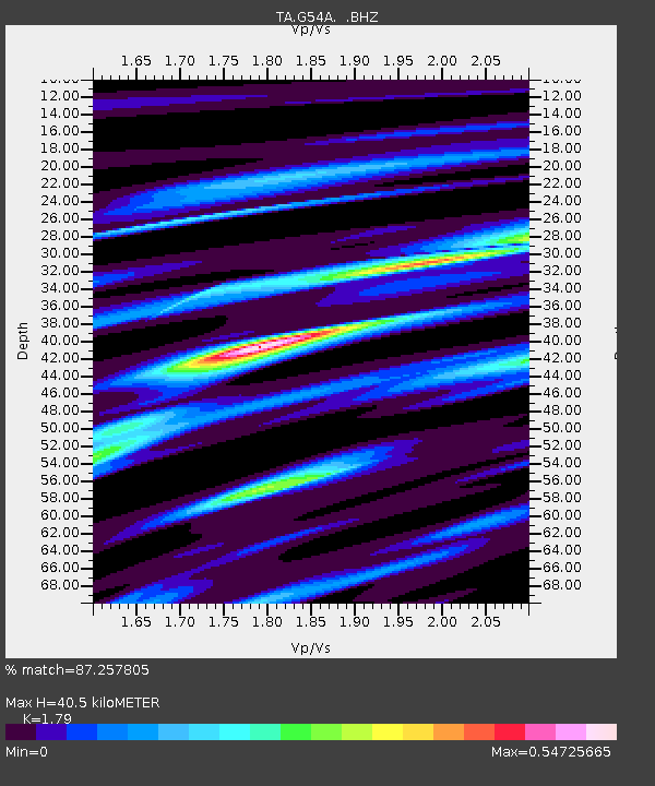
| Estimated Moho Depth: |
40.5 km |
| Estimated Crust Vp/Vs: |
1.79 |
| Assumed Crust Vp: |
6.577 km/s |
| Estimated Crust Vs: |
3.674 km/s |
| Estimated Crust Poisson's Ratio: |
0.27 |
|
| Radial Match: |
87.257805 % |
| Radial Bump: |
355 |
| Transverse Match: |
66.65893 % |
| Transverse Bump: |
400 |
| SOD ConfigId: |
790520 |
| Insert Time: |
2014-09-20 07:41:04.959 +0000 |
| GWidth: |
2.5 |
| Max Bumps: |
400 |
| Tol: |
0.001 |
|

Signal To Noise
| Channel | StoN | STA | LTA |
| TA:G54A: :BHZ:20140906T07:04:45.87499Z | 9.819335 | 1.871128E-6 | 1.9055545E-7 |
| TA:G54A: :BHN:20140906T07:04:45.87499Z | 5.1256886 | 6.190112E-7 | 1.2076644E-7 |
| TA:G54A: :BHE:20140906T07:04:45.87499Z | 3.2038963 | 4.6439314E-7 | 1.4494637E-7 |
| Arrivals |
| Ps | 5.0 SECOND |
| PpPs | 17 SECOND |
| PsPs/PpSs | 22 SECOND |


