You are here: Home > Network List > TA - USArray Transportable Network (new EarthScope stations) Stations List
> Station G59A Clarenceville, QC, USA > Earthquake Result Viewer
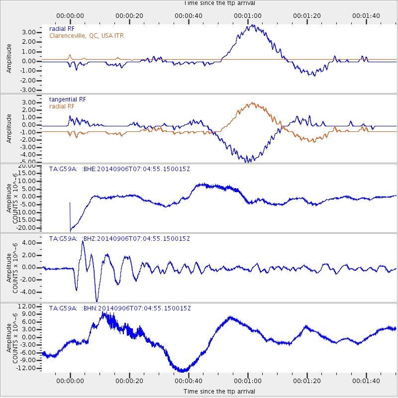
G59A Clarenceville, QC, USA - Earthquake Result Viewer
*The percent match for this event was below the threshold and hence no stack was calculated.
| Earthquake location: |
Easter Island Region |
| Earthquake latitude/longitude: |
-26.6/-114.5 |
| Earthquake time(UTC): |
2014/09/06 (249) 06:53:13 GMT |
| Earthquake Depth: |
10 km |
| Earthquake Magnitude: |
6.1 MB |
| Earthquake Catalog/Contributor: |
NEIC PDE/NEIC COMCAT |
|
| Network: |
TA USArray Transportable Network (new EarthScope stations) |
| Station: |
G59A Clarenceville, QC, USA |
| Lat/Lon: |
45.08 N/73.18 W |
| Elevation: |
36 m |
|
| Distance: |
80.7 deg |
| Az: |
28.27 deg |
| Baz: |
216.757 deg |
| Ray Param: |
$rayparam |
*The percent match for this event was below the threshold and hence was not used in the summary stack. |
|
| Radial Match: |
21.01798 % |
| Radial Bump: |
400 |
| Transverse Match: |
23.939774 % |
| Transverse Bump: |
400 |
| SOD ConfigId: |
790520 |
| Insert Time: |
2014-09-20 07:41:15.006 +0000 |
| GWidth: |
2.5 |
| Max Bumps: |
400 |
| Tol: |
0.001 |
|
Signal To Noise
| Channel | StoN | STA | LTA |
| TA:G59A: :BHZ:20140906T07:04:55.150015Z | 10.050758 | 2.1559645E-6 | 2.1450765E-7 |
| TA:G59A: :BHN:20140906T07:04:55.150015Z | 0.65207547 | 9.661599E-6 | 1.4816687E-5 |
| TA:G59A: :BHE:20140906T07:04:55.150015Z | 0.25712684 | 1.7123577E-6 | 6.6595835E-6 |
| Arrivals |
| Ps | |
| PpPs | |
| PsPs/PpSs | |


