You are here: Home > Network List > TA - USArray Transportable Network (new EarthScope stations) Stations List
> Station G63A Kingsbury, ME, USA > Earthquake Result Viewer
G63A Kingsbury, ME, USA - Earthquake Result Viewer
| Earthquake location: |
Easter Island Region |
| Earthquake latitude/longitude: |
-26.6/-114.5 |
| Earthquake time(UTC): |
2014/09/06 (249) 06:53:13 GMT |
| Earthquake Depth: |
10 km |
| Earthquake Magnitude: |
6.1 MB |
| Earthquake Catalog/Contributor: |
NEIC PDE/NEIC COMCAT |
|
| Network: |
TA USArray Transportable Network (new EarthScope stations) |
| Station: |
G63A Kingsbury, ME, USA |
| Lat/Lon: |
45.11 N/69.62 W |
| Elevation: |
363 m |
|
| Distance: |
82.3 deg |
| Az: |
30.255 deg |
| Baz: |
219.567 deg |
| Ray Param: |
0.047010943 |
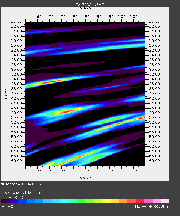
| Estimated Moho Depth: |
49.5 km |
| Estimated Crust Vp/Vs: |
2.10 |
| Assumed Crust Vp: |
6.419 km/s |
| Estimated Crust Vs: |
3.06 km/s |
| Estimated Crust Poisson's Ratio: |
0.35 |
|
| Radial Match: |
87.841995 % |
| Radial Bump: |
400 |
| Transverse Match: |
76.78596 % |
| Transverse Bump: |
400 |
| SOD ConfigId: |
790520 |
| Insert Time: |
2014-09-20 07:41:24.372 +0000 |
| GWidth: |
2.5 |
| Max Bumps: |
400 |
| Tol: |
0.001 |
|
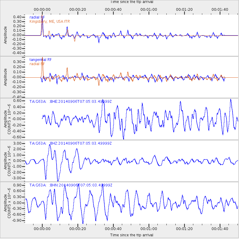
Signal To Noise
| Channel | StoN | STA | LTA |
| TA:G63A: :BHZ:20140906T07:05:03.49999Z | 8.14596 | 1.6716034E-6 | 2.0520645E-7 |
| TA:G63A: :BHN:20140906T07:05:03.49999Z | 2.278368 | 4.1716342E-7 | 1.8309748E-7 |
| TA:G63A: :BHE:20140906T07:05:03.49999Z | 3.109346 | 3.229836E-7 | 1.0387509E-7 |
| Arrivals |
| Ps | 8.7 SECOND |
| PpPs | 23 SECOND |
| PsPs/PpSs | 32 SECOND |


