You are here: Home > Network List > TA - USArray Transportable Network (new EarthScope stations) Stations List
> Station H59A Cadyville, NY, USA > Earthquake Result Viewer
H59A Cadyville, NY, USA - Earthquake Result Viewer
| Earthquake location: |
Easter Island Region |
| Earthquake latitude/longitude: |
-26.6/-114.5 |
| Earthquake time(UTC): |
2014/09/06 (249) 06:53:13 GMT |
| Earthquake Depth: |
10 km |
| Earthquake Magnitude: |
6.1 MB |
| Earthquake Catalog/Contributor: |
NEIC PDE/NEIC COMCAT |
|
| Network: |
TA USArray Transportable Network (new EarthScope stations) |
| Station: |
H59A Cadyville, NY, USA |
| Lat/Lon: |
44.65 N/73.69 W |
| Elevation: |
355 m |
|
| Distance: |
80.1 deg |
| Az: |
28.238 deg |
| Baz: |
216.393 deg |
| Ray Param: |
0.048501782 |
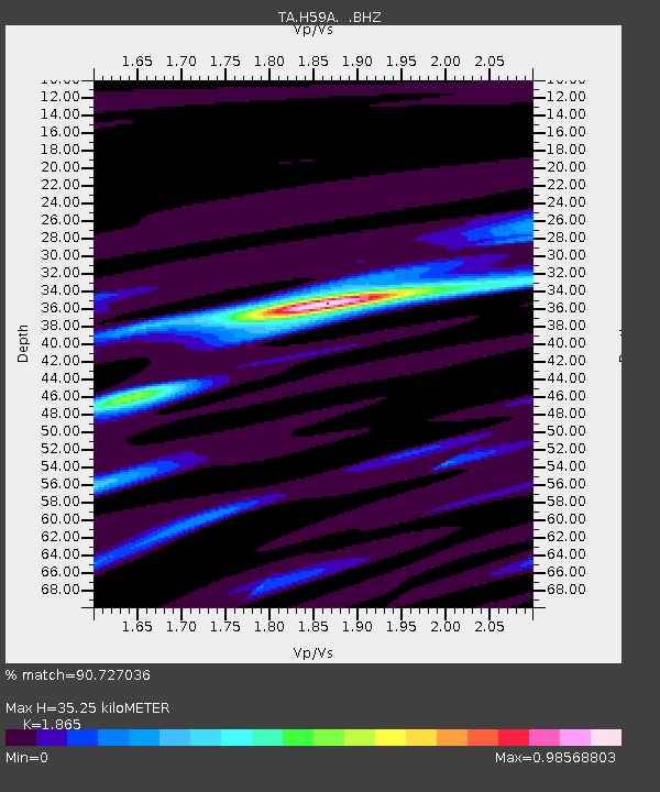
| Estimated Moho Depth: |
35.25 km |
| Estimated Crust Vp/Vs: |
1.87 |
| Assumed Crust Vp: |
6.419 km/s |
| Estimated Crust Vs: |
3.442 km/s |
| Estimated Crust Poisson's Ratio: |
0.30 |
|
| Radial Match: |
90.727036 % |
| Radial Bump: |
290 |
| Transverse Match: |
73.34406 % |
| Transverse Bump: |
400 |
| SOD ConfigId: |
790520 |
| Insert Time: |
2014-09-20 07:42:10.531 +0000 |
| GWidth: |
2.5 |
| Max Bumps: |
400 |
| Tol: |
0.001 |
|

Signal To Noise
| Channel | StoN | STA | LTA |
| TA:H59A: :BHZ:20140906T07:04:52.100027Z | 14.159946 | 1.973458E-6 | 1.3936902E-7 |
| TA:H59A: :BHN:20140906T07:04:52.100027Z | 5.224439 | 5.9800425E-7 | 1.1446287E-7 |
| TA:H59A: :BHE:20140906T07:04:52.100027Z | 2.7639837 | 4.90735E-7 | 1.7754628E-7 |
| Arrivals |
| Ps | 4.9 SECOND |
| PpPs | 15 SECOND |
| PsPs/PpSs | 20 SECOND |


