You are here: Home > Network List > TA - USArray Transportable Network (new EarthScope stations) Stations List
> Station I63A Otisfield, ME, USA > Earthquake Result Viewer
I63A Otisfield, ME, USA - Earthquake Result Viewer
| Earthquake location: |
Easter Island Region |
| Earthquake latitude/longitude: |
-26.6/-114.5 |
| Earthquake time(UTC): |
2014/09/06 (249) 06:53:13 GMT |
| Earthquake Depth: |
10 km |
| Earthquake Magnitude: |
6.1 MB |
| Earthquake Catalog/Contributor: |
NEIC PDE/NEIC COMCAT |
|
| Network: |
TA USArray Transportable Network (new EarthScope stations) |
| Station: |
I63A Otisfield, ME, USA |
| Lat/Lon: |
44.05 N/70.58 W |
| Elevation: |
177 m |
|
| Distance: |
81.0 deg |
| Az: |
30.397 deg |
| Baz: |
218.914 deg |
| Ray Param: |
0.047894098 |
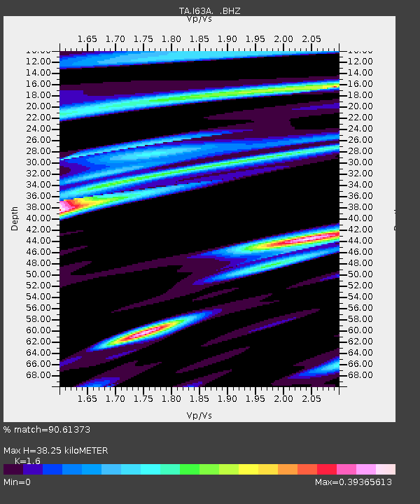
| Estimated Moho Depth: |
38.25 km |
| Estimated Crust Vp/Vs: |
1.60 |
| Assumed Crust Vp: |
6.419 km/s |
| Estimated Crust Vs: |
4.012 km/s |
| Estimated Crust Poisson's Ratio: |
0.18 |
|
| Radial Match: |
90.61373 % |
| Radial Bump: |
400 |
| Transverse Match: |
78.20875 % |
| Transverse Bump: |
400 |
| SOD ConfigId: |
790520 |
| Insert Time: |
2014-09-20 07:43:07.677 +0000 |
| GWidth: |
2.5 |
| Max Bumps: |
400 |
| Tol: |
0.001 |
|

Signal To Noise
| Channel | StoN | STA | LTA |
| TA:I63A: :BHZ:20140906T07:04:56.87499Z | 11.087319 | 1.6325889E-6 | 1.472483E-7 |
| TA:I63A: :BHN:20140906T07:04:56.87499Z | 2.5763147 | 4.477878E-7 | 1.7380945E-7 |
| TA:I63A: :BHE:20140906T07:04:56.87499Z | 3.3217947 | 3.5664476E-7 | 1.07365075E-7 |
| Arrivals |
| Ps | 3.7 SECOND |
| PpPs | 15 SECOND |
| PsPs/PpSs | 19 SECOND |


