You are here: Home > Network List > TA - USArray Transportable Network (new EarthScope stations) Stations List
> Station J01E Myrtle Point, OR, USA > Earthquake Result Viewer
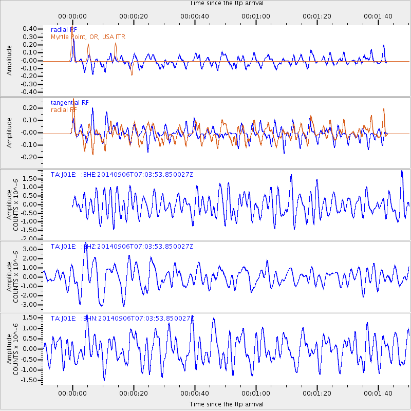
J01E Myrtle Point, OR, USA - Earthquake Result Viewer
*The percent match for this event was below the threshold and hence no stack was calculated.
| Earthquake location: |
Easter Island Region |
| Earthquake latitude/longitude: |
-26.6/-114.5 |
| Earthquake time(UTC): |
2014/09/06 (249) 06:53:13 GMT |
| Earthquake Depth: |
10 km |
| Earthquake Magnitude: |
6.1 MB |
| Earthquake Catalog/Contributor: |
NEIC PDE/NEIC COMCAT |
|
| Network: |
TA USArray Transportable Network (new EarthScope stations) |
| Station: |
J01E Myrtle Point, OR, USA |
| Lat/Lon: |
43.16 N/123.93 W |
| Elevation: |
128 m |
|
| Distance: |
70.0 deg |
| Az: |
352.635 deg |
| Baz: |
170.977 deg |
| Ray Param: |
$rayparam |
*The percent match for this event was below the threshold and hence was not used in the summary stack. |
|
| Radial Match: |
77.92336 % |
| Radial Bump: |
400 |
| Transverse Match: |
56.79296 % |
| Transverse Bump: |
400 |
| SOD ConfigId: |
790520 |
| Insert Time: |
2014-09-20 07:43:12.773 +0000 |
| GWidth: |
2.5 |
| Max Bumps: |
400 |
| Tol: |
0.001 |
|
Signal To Noise
| Channel | StoN | STA | LTA |
| TA:J01E: :BHZ:20140906T07:03:53.850027Z | 3.1973865 | 1.9090514E-6 | 5.970662E-7 |
| TA:J01E: :BHN:20140906T07:03:53.850027Z | 1.5416937 | 6.2395725E-7 | 4.0472193E-7 |
| TA:J01E: :BHE:20140906T07:03:53.850027Z | 0.70273834 | 4.2006477E-7 | 5.9775414E-7 |
| Arrivals |
| Ps | |
| PpPs | |
| PsPs/PpSs | |


