You are here: Home > Network List > TA - USArray Transportable Network (new EarthScope stations) Stations List
> Station L44A Lake County Forest Preserve, Grayslake, IL, USA > Earthquake Result Viewer
L44A Lake County Forest Preserve, Grayslake, IL, USA - Earthquake Result Viewer
| Earthquake location: |
Easter Island Region |
| Earthquake latitude/longitude: |
-26.6/-114.5 |
| Earthquake time(UTC): |
2014/09/06 (249) 06:53:13 GMT |
| Earthquake Depth: |
10 km |
| Earthquake Magnitude: |
6.1 MB |
| Earthquake Catalog/Contributor: |
NEIC PDE/NEIC COMCAT |
|
| Network: |
TA USArray Transportable Network (new EarthScope stations) |
| Station: |
L44A Lake County Forest Preserve, Grayslake, IL, USA |
| Lat/Lon: |
42.18 N/87.91 W |
| Elevation: |
202 m |
|
| Distance: |
72.7 deg |
| Az: |
20.357 deg |
| Baz: |
204.768 deg |
| Ray Param: |
0.053475138 |
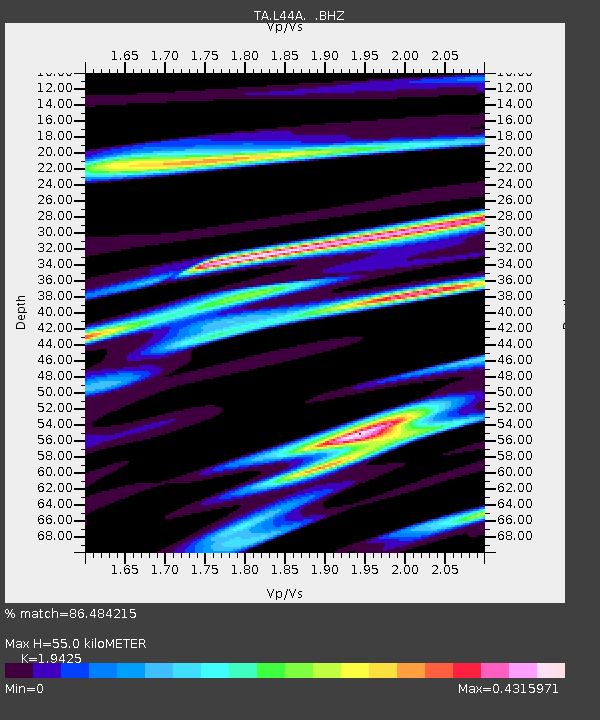
| Estimated Moho Depth: |
55.0 km |
| Estimated Crust Vp/Vs: |
1.94 |
| Assumed Crust Vp: |
6.483 km/s |
| Estimated Crust Vs: |
3.337 km/s |
| Estimated Crust Poisson's Ratio: |
0.32 |
|
| Radial Match: |
86.484215 % |
| Radial Bump: |
400 |
| Transverse Match: |
74.934685 % |
| Transverse Bump: |
400 |
| SOD ConfigId: |
790520 |
| Insert Time: |
2014-09-20 07:44:31.113 +0000 |
| GWidth: |
2.5 |
| Max Bumps: |
400 |
| Tol: |
0.001 |
|

Signal To Noise
| Channel | StoN | STA | LTA |
| TA:L44A: :BHZ:20140906T07:04:10.325002Z | 11.484657 | 1.921557E-6 | 1.6731514E-7 |
| TA:L44A: :BHN:20140906T07:04:10.325002Z | 5.0139213 | 7.595316E-7 | 1.5148454E-7 |
| TA:L44A: :BHE:20140906T07:04:10.325002Z | 2.6390846 | 4.228412E-7 | 1.6022268E-7 |
| Arrivals |
| Ps | 8.3 SECOND |
| PpPs | 24 SECOND |
| PsPs/PpSs | 32 SECOND |


