You are here: Home > Network List > TA - USArray Transportable Network (new EarthScope stations) Stations List
> Station L53A Girard, PA, USA > Earthquake Result Viewer
L53A Girard, PA, USA - Earthquake Result Viewer
| Earthquake location: |
Easter Island Region |
| Earthquake latitude/longitude: |
-26.6/-114.5 |
| Earthquake time(UTC): |
2014/09/06 (249) 06:53:13 GMT |
| Earthquake Depth: |
10 km |
| Earthquake Magnitude: |
6.1 MB |
| Earthquake Catalog/Contributor: |
NEIC PDE/NEIC COMCAT |
|
| Network: |
TA USArray Transportable Network (new EarthScope stations) |
| Station: |
L53A Girard, PA, USA |
| Lat/Lon: |
41.95 N/80.26 W |
| Elevation: |
355 m |
|
| Distance: |
75.2 deg |
| Az: |
25.696 deg |
| Baz: |
211.356 deg |
| Ray Param: |
0.051825017 |
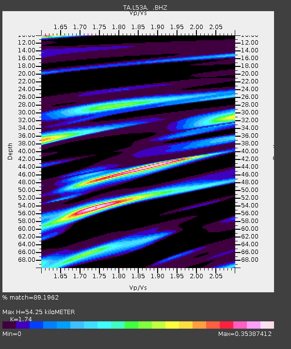
| Estimated Moho Depth: |
54.25 km |
| Estimated Crust Vp/Vs: |
1.74 |
| Assumed Crust Vp: |
6.483 km/s |
| Estimated Crust Vs: |
3.726 km/s |
| Estimated Crust Poisson's Ratio: |
0.25 |
|
| Radial Match: |
89.1962 % |
| Radial Bump: |
357 |
| Transverse Match: |
72.845146 % |
| Transverse Bump: |
400 |
| SOD ConfigId: |
790520 |
| Insert Time: |
2014-09-20 07:44:32.377 +0000 |
| GWidth: |
2.5 |
| Max Bumps: |
400 |
| Tol: |
0.001 |
|

Signal To Noise
| Channel | StoN | STA | LTA |
| TA:L53A: :BHZ:20140906T07:04:24.850027Z | 8.571451 | 1.5870031E-6 | 1.8514989E-7 |
| TA:L53A: :BHN:20140906T07:04:24.850027Z | 3.3268507 | 5.26451E-7 | 1.5824305E-7 |
| TA:L53A: :BHE:20140906T07:04:24.850027Z | 2.503918 | 4.453285E-7 | 1.7785267E-7 |
| Arrivals |
| Ps | 6.4 SECOND |
| PpPs | 22 SECOND |
| PsPs/PpSs | 29 SECOND |


