You are here: Home > Network List > TA - USArray Transportable Network (new EarthScope stations) Stations List
> Station L64A Middleborough, MA, USA > Earthquake Result Viewer
L64A Middleborough, MA, USA - Earthquake Result Viewer
| Earthquake location: |
Easter Island Region |
| Earthquake latitude/longitude: |
-26.6/-114.5 |
| Earthquake time(UTC): |
2014/09/06 (249) 06:53:13 GMT |
| Earthquake Depth: |
10 km |
| Earthquake Magnitude: |
6.1 MB |
| Earthquake Catalog/Contributor: |
NEIC PDE/NEIC COMCAT |
|
| Network: |
TA USArray Transportable Network (new EarthScope stations) |
| Station: |
L64A Middleborough, MA, USA |
| Lat/Lon: |
41.94 N/70.84 W |
| Elevation: |
17 m |
|
| Distance: |
79.2 deg |
| Az: |
31.595 deg |
| Baz: |
218.944 deg |
| Ray Param: |
0.04909848 |
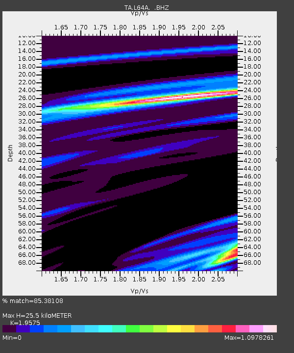
| Estimated Moho Depth: |
25.5 km |
| Estimated Crust Vp/Vs: |
1.96 |
| Assumed Crust Vp: |
6.472 km/s |
| Estimated Crust Vs: |
3.306 km/s |
| Estimated Crust Poisson's Ratio: |
0.32 |
|
| Radial Match: |
85.38108 % |
| Radial Bump: |
400 |
| Transverse Match: |
58.070618 % |
| Transverse Bump: |
400 |
| SOD ConfigId: |
790520 |
| Insert Time: |
2014-09-20 07:45:00.718 +0000 |
| GWidth: |
2.5 |
| Max Bumps: |
400 |
| Tol: |
0.001 |
|

Signal To Noise
| Channel | StoN | STA | LTA |
| TA:L64A: :BHZ:20140906T07:04:47.400015Z | 8.582307 | 1.5584349E-6 | 1.8158696E-7 |
| TA:L64A: :BHN:20140906T07:04:47.400015Z | 3.318712 | 5.1811395E-7 | 1.5611899E-7 |
| TA:L64A: :BHE:20140906T07:04:47.400015Z | 2.5193658 | 4.1114325E-7 | 1.6319315E-7 |
| Arrivals |
| Ps | 3.9 SECOND |
| PpPs | 11 SECOND |
| PsPs/PpSs | 15 SECOND |


