You are here: Home > Network List > TA - USArray Transportable Network (new EarthScope stations) Stations List
> Station N02D Trinity Center, CA, USA > Earthquake Result Viewer
N02D Trinity Center, CA, USA - Earthquake Result Viewer
| Earthquake location: |
Easter Island Region |
| Earthquake latitude/longitude: |
-26.6/-114.5 |
| Earthquake time(UTC): |
2014/09/06 (249) 06:53:13 GMT |
| Earthquake Depth: |
10 km |
| Earthquake Magnitude: |
6.1 MB |
| Earthquake Catalog/Contributor: |
NEIC PDE/NEIC COMCAT |
|
| Network: |
TA USArray Transportable Network (new EarthScope stations) |
| Station: |
N02D Trinity Center, CA, USA |
| Lat/Lon: |
40.97 N/122.71 W |
| Elevation: |
937 m |
|
| Distance: |
67.7 deg |
| Az: |
353.256 deg |
| Baz: |
172.02 deg |
| Ray Param: |
0.056792066 |
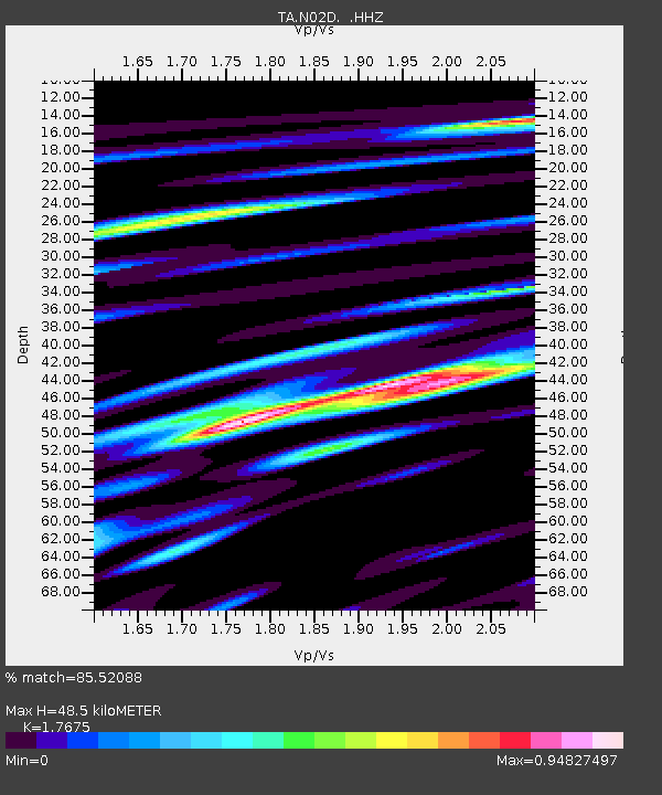
| Estimated Moho Depth: |
48.5 km |
| Estimated Crust Vp/Vs: |
1.77 |
| Assumed Crust Vp: |
6.566 km/s |
| Estimated Crust Vs: |
3.715 km/s |
| Estimated Crust Poisson's Ratio: |
0.26 |
|
| Radial Match: |
85.52088 % |
| Radial Bump: |
356 |
| Transverse Match: |
80.36274 % |
| Transverse Bump: |
397 |
| SOD ConfigId: |
790520 |
| Insert Time: |
2014-09-20 07:45:53.238 +0000 |
| GWidth: |
2.5 |
| Max Bumps: |
400 |
| Tol: |
0.001 |
|

Signal To Noise
| Channel | StoN | STA | LTA |
| TA:N02D: :HHZ:20140906T07:03:39.600027Z | 12.152318 | 1.6171414E-6 | 1.3307266E-7 |
| TA:N02D: :HHN:20140906T07:03:39.600027Z | 4.595948 | 8.0444454E-7 | 1.750334E-7 |
| TA:N02D: :HHE:20140906T07:03:39.600027Z | 7.601022 | 6.6823844E-7 | 8.791429E-8 |
| Arrivals |
| Ps | 5.9 SECOND |
| PpPs | 20 SECOND |
| PsPs/PpSs | 26 SECOND |


