You are here: Home > Network List > TA - USArray Transportable Network (new EarthScope stations) Stations List
> Station N57A Milroy, PA, USA > Earthquake Result Viewer
N57A Milroy, PA, USA - Earthquake Result Viewer

| Earthquake location: |
Easter Island Region |
| Earthquake latitude/longitude: |
-26.6/-114.5 |
| Earthquake time(UTC): |
2014/09/06 (249) 06:53:13 GMT |
| Earthquake Depth: |
10 km |
| Earthquake Magnitude: |
6.1 MB |
| Earthquake Catalog/Contributor: |
NEIC PDE/NEIC COMCAT |
|
| Network: |
TA USArray Transportable Network (new EarthScope stations) |
| Station: |
N57A Milroy, PA, USA |
| Lat/Lon: |
40.76 N/77.55 W |
| Elevation: |
306 m |
|
| Distance: |
75.3 deg |
| Az: |
28.14 deg |
| Baz: |
213.762 deg |
| Ray Param: |
0.051767394 |
| Estimated Moho Depth: |
40.25 km |
| Estimated Crust Vp/Vs: |
1.66 |
| Assumed Crust Vp: |
6.121 km/s |
| Estimated Crust Vs: |
3.693 km/s |
| Estimated Crust Poisson's Ratio: |
0.21 |
|
| Radial Match: |
90.83689 % |
| Radial Bump: |
400 |
| Transverse Match: |
83.56476 % |
| Transverse Bump: |
400 |
| SOD ConfigId: |
790520 |
| Insert Time: |
2014-09-20 07:46:12.148 +0000 |
| GWidth: |
2.5 |
| Max Bumps: |
400 |
| Tol: |
0.001 |
|
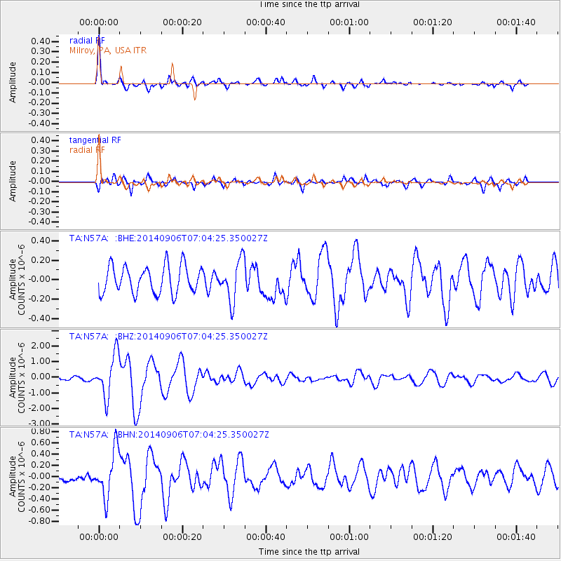
Signal To Noise
| Channel | StoN | STA | LTA |
| TA:N57A: :BHZ:20140906T07:04:25.350027Z | 14.438396 | 1.3946906E-6 | 9.659595E-8 |
| TA:N57A: :BHN:20140906T07:04:25.350027Z | 5.9693174 | 4.279273E-7 | 7.168781E-8 |
| TA:N57A: :BHE:20140906T07:04:25.350027Z | 1.5419338 | 2.164041E-7 | 1.4034592E-7 |
| Arrivals |
| Ps | 4.5 SECOND |
| PpPs | 17 SECOND |
| PsPs/PpSs | 21 SECOND |


