You are here: Home > Network List > TA - USArray Transportable Network (new EarthScope stations) Stations List
> Station O51A Pataskala, OH, USA > Earthquake Result Viewer
O51A Pataskala, OH, USA - Earthquake Result Viewer

| Earthquake location: |
Easter Island Region |
| Earthquake latitude/longitude: |
-26.6/-114.5 |
| Earthquake time(UTC): |
2014/09/06 (249) 06:53:13 GMT |
| Earthquake Depth: |
10 km |
| Earthquake Magnitude: |
6.1 MB |
| Earthquake Catalog/Contributor: |
NEIC PDE/NEIC COMCAT |
|
| Network: |
TA USArray Transportable Network (new EarthScope stations) |
| Station: |
O51A Pataskala, OH, USA |
| Lat/Lon: |
40.15 N/82.61 W |
| Elevation: |
380 m |
|
| Distance: |
72.7 deg |
| Az: |
25.059 deg |
| Baz: |
209.645 deg |
| Ray Param: |
0.053456582 |
| Estimated Moho Depth: |
50.75 km |
| Estimated Crust Vp/Vs: |
1.70 |
| Assumed Crust Vp: |
6.498 km/s |
| Estimated Crust Vs: |
3.816 km/s |
| Estimated Crust Poisson's Ratio: |
0.24 |
|
| Radial Match: |
90.822334 % |
| Radial Bump: |
400 |
| Transverse Match: |
68.83728 % |
| Transverse Bump: |
400 |
| SOD ConfigId: |
790520 |
| Insert Time: |
2014-09-20 07:46:33.267 +0000 |
| GWidth: |
2.5 |
| Max Bumps: |
400 |
| Tol: |
0.001 |
|
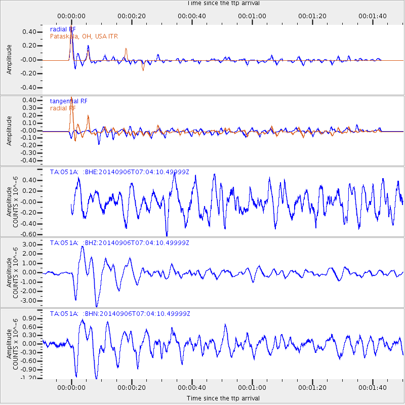
Signal To Noise
| Channel | StoN | STA | LTA |
| TA:O51A: :BHZ:20140906T07:04:10.49999Z | 13.209829 | 1.6693562E-6 | 1.2637227E-7 |
| TA:O51A: :BHN:20140906T07:04:10.49999Z | 5.05616 | 6.117915E-7 | 1.2099923E-7 |
| TA:O51A: :BHE:20140906T07:04:10.49999Z | 1.6420274 | 3.0891377E-7 | 1.881295E-7 |
| Arrivals |
| Ps | 5.7 SECOND |
| PpPs | 20 SECOND |
| PsPs/PpSs | 26 SECOND |


