You are here: Home > Network List > TA - USArray Transportable Network (new EarthScope stations) Stations List
> Station P55A Reedsville, WV, USA > Earthquake Result Viewer
P55A Reedsville, WV, USA - Earthquake Result Viewer
| Earthquake location: |
Easter Island Region |
| Earthquake latitude/longitude: |
-26.6/-114.5 |
| Earthquake time(UTC): |
2014/09/06 (249) 06:53:13 GMT |
| Earthquake Depth: |
10 km |
| Earthquake Magnitude: |
6.1 MB |
| Earthquake Catalog/Contributor: |
NEIC PDE/NEIC COMCAT |
|
| Network: |
TA USArray Transportable Network (new EarthScope stations) |
| Station: |
P55A Reedsville, WV, USA |
| Lat/Lon: |
39.51 N/79.83 W |
| Elevation: |
551 m |
|
| Distance: |
73.3 deg |
| Az: |
27.322 deg |
| Baz: |
212.079 deg |
| Ray Param: |
0.05309618 |
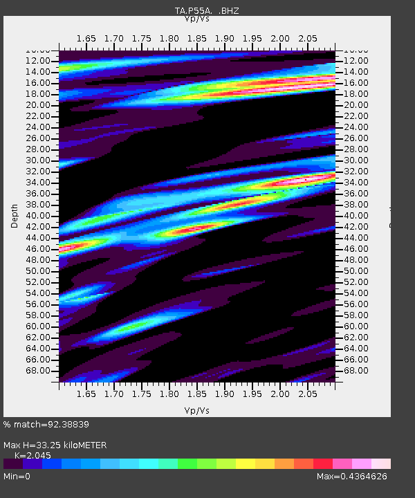
| Estimated Moho Depth: |
33.25 km |
| Estimated Crust Vp/Vs: |
2.05 |
| Assumed Crust Vp: |
6.159 km/s |
| Estimated Crust Vs: |
3.012 km/s |
| Estimated Crust Poisson's Ratio: |
0.34 |
|
| Radial Match: |
92.38839 % |
| Radial Bump: |
395 |
| Transverse Match: |
79.64837 % |
| Transverse Bump: |
400 |
| SOD ConfigId: |
790520 |
| Insert Time: |
2014-09-20 07:47:11.418 +0000 |
| GWidth: |
2.5 |
| Max Bumps: |
400 |
| Tol: |
0.001 |
|
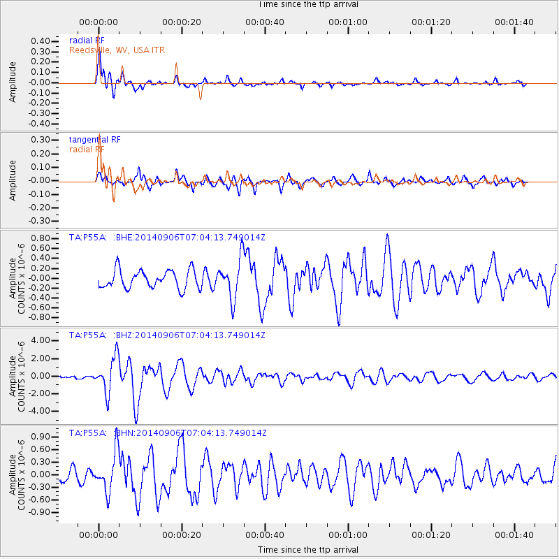
Signal To Noise
| Channel | StoN | STA | LTA |
| TA:P55A: :BHZ:20140906T07:04:13.749014Z | 7.497253 | 2.0612792E-6 | 2.7493792E-7 |
| TA:P55A: :BHN:20140906T07:04:13.749014Z | 4.182794 | 4.887492E-7 | 1.1684754E-7 |
| TA:P55A: :BHE:20140906T07:04:13.749014Z | 2.3039227 | 4.1976438E-7 | 1.8219552E-7 |
| Arrivals |
| Ps | 5.8 SECOND |
| PpPs | 16 SECOND |
| PsPs/PpSs | 22 SECOND |


