You are here: Home > Network List > TA - USArray Transportable Network (new EarthScope stations) Stations List
> Station P56A Dayton Farm, Ripley, WV, USA > Earthquake Result Viewer
P56A Dayton Farm, Ripley, WV, USA - Earthquake Result Viewer
| Earthquake location: |
Easter Island Region |
| Earthquake latitude/longitude: |
-26.6/-114.5 |
| Earthquake time(UTC): |
2014/09/06 (249) 06:53:13 GMT |
| Earthquake Depth: |
10 km |
| Earthquake Magnitude: |
6.1 MB |
| Earthquake Catalog/Contributor: |
NEIC PDE/NEIC COMCAT |
|
| Network: |
TA USArray Transportable Network (new EarthScope stations) |
| Station: |
P56A Dayton Farm, Ripley, WV, USA |
| Lat/Lon: |
39.50 N/78.84 W |
| Elevation: |
249 m |
|
| Distance: |
73.7 deg |
| Az: |
27.996 deg |
| Baz: |
212.897 deg |
| Ray Param: |
0.052825566 |
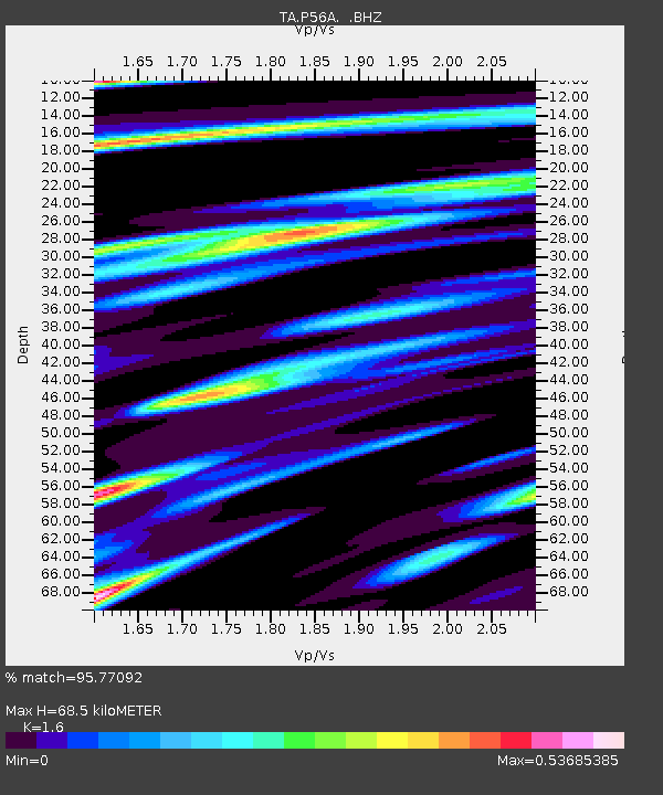
| Estimated Moho Depth: |
68.5 km |
| Estimated Crust Vp/Vs: |
1.60 |
| Assumed Crust Vp: |
6.159 km/s |
| Estimated Crust Vs: |
3.849 km/s |
| Estimated Crust Poisson's Ratio: |
0.18 |
|
| Radial Match: |
95.77092 % |
| Radial Bump: |
314 |
| Transverse Match: |
76.99857 % |
| Transverse Bump: |
400 |
| SOD ConfigId: |
790520 |
| Insert Time: |
2014-09-20 07:47:13.335 +0000 |
| GWidth: |
2.5 |
| Max Bumps: |
400 |
| Tol: |
0.001 |
|

Signal To Noise
| Channel | StoN | STA | LTA |
| TA:P56A: :BHZ:20140906T07:04:16.150015Z | 19.03657 | 1.8509628E-6 | 9.723195E-8 |
| TA:P56A: :BHN:20140906T07:04:16.150015Z | 10.903112 | 6.7495614E-7 | 6.1904906E-8 |
| TA:P56A: :BHE:20140906T07:04:16.150015Z | 4.060998 | 3.756909E-7 | 9.251197E-8 |
| Arrivals |
| Ps | 6.9 SECOND |
| PpPs | 28 SECOND |
| PsPs/PpSs | 35 SECOND |


