You are here: Home > Network List > TA - USArray Transportable Network (new EarthScope stations) Stations List
> Station R56A Bull Pasture Mountain, McDowell, VA, USA > Earthquake Result Viewer
R56A Bull Pasture Mountain, McDowell, VA, USA - Earthquake Result Viewer
| Earthquake location: |
Easter Island Region |
| Earthquake latitude/longitude: |
-26.6/-114.5 |
| Earthquake time(UTC): |
2014/09/06 (249) 06:53:13 GMT |
| Earthquake Depth: |
10 km |
| Earthquake Magnitude: |
6.1 MB |
| Earthquake Catalog/Contributor: |
NEIC PDE/NEIC COMCAT |
|
| Network: |
TA USArray Transportable Network (new EarthScope stations) |
| Station: |
R56A Bull Pasture Mountain, McDowell, VA, USA |
| Lat/Lon: |
38.41 N/79.40 W |
| Elevation: |
902 m |
|
| Distance: |
72.5 deg |
| Az: |
28.229 deg |
| Baz: |
212.611 deg |
| Ray Param: |
0.053588938 |
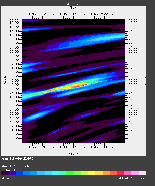
| Estimated Moho Depth: |
42.5 km |
| Estimated Crust Vp/Vs: |
1.88 |
| Assumed Crust Vp: |
6.159 km/s |
| Estimated Crust Vs: |
3.276 km/s |
| Estimated Crust Poisson's Ratio: |
0.30 |
|
| Radial Match: |
96.21699 % |
| Radial Bump: |
253 |
| Transverse Match: |
81.961555 % |
| Transverse Bump: |
400 |
| SOD ConfigId: |
790520 |
| Insert Time: |
2014-09-20 07:48:08.190 +0000 |
| GWidth: |
2.5 |
| Max Bumps: |
400 |
| Tol: |
0.001 |
|

Signal To Noise
| Channel | StoN | STA | LTA |
| TA:R56A: :BHZ:20140906T07:04:09.299978Z | 18.51268 | 1.6400886E-6 | 8.859272E-8 |
| TA:R56A: :BHN:20140906T07:04:09.299978Z | 8.358324 | 7.519645E-7 | 8.9965944E-8 |
| TA:R56A: :BHE:20140906T07:04:09.299978Z | 3.8300917 | 4.1869055E-7 | 1.0931606E-7 |
| Arrivals |
| Ps | 6.3 SECOND |
| PpPs | 19 SECOND |
| PsPs/PpSs | 26 SECOND |


