You are here: Home > Network List > TA - USArray Transportable Network (new EarthScope stations) Stations List
> Station R57A Stanardsville, VA, USA > Earthquake Result Viewer
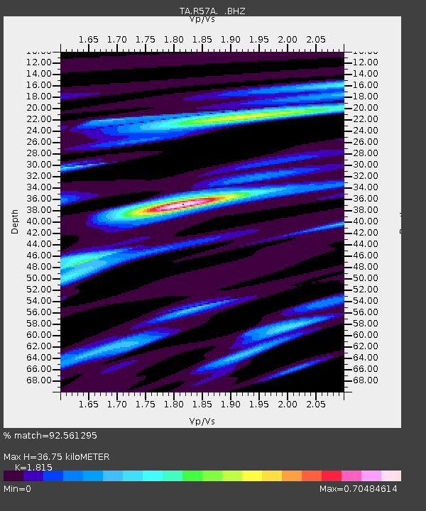
R57A Stanardsville, VA, USA - Earthquake Result Viewer
| Earthquake location: |
Easter Island Region |
| Earthquake latitude/longitude: |
-26.6/-114.5 |
| Earthquake time(UTC): |
2014/09/06 (249) 06:53:13 GMT |
| Earthquake Depth: |
10 km |
| Earthquake Magnitude: |
6.1 MB |
| Earthquake Catalog/Contributor: |
NEIC PDE/NEIC COMCAT |
|
| Network: |
TA USArray Transportable Network (new EarthScope stations) |
| Station: |
R57A Stanardsville, VA, USA |
| Lat/Lon: |
38.30 N/78.52 W |
| Elevation: |
230 m |
|
| Distance: |
72.8 deg |
| Az: |
28.9 deg |
| Baz: |
213.354 deg |
| Ray Param: |
0.053402577 |
| Estimated Moho Depth: |
36.75 km |
| Estimated Crust Vp/Vs: |
1.82 |
| Assumed Crust Vp: |
6.159 km/s |
| Estimated Crust Vs: |
3.393 km/s |
| Estimated Crust Poisson's Ratio: |
0.28 |
|
| Radial Match: |
92.561295 % |
| Radial Bump: |
298 |
| Transverse Match: |
70.64074 % |
| Transverse Bump: |
400 |
| SOD ConfigId: |
790520 |
| Insert Time: |
2014-09-20 07:48:10.445 +0000 |
| GWidth: |
2.5 |
| Max Bumps: |
400 |
| Tol: |
0.001 |
|

Signal To Noise
| Channel | StoN | STA | LTA |
| TA:R57A: :BHZ:20140906T07:04:10.99999Z | 17.357306 | 1.3099735E-6 | 7.547102E-8 |
| TA:R57A: :BHN:20140906T07:04:10.99999Z | 6.7155857 | 6.277679E-7 | 9.347925E-8 |
| TA:R57A: :BHE:20140906T07:04:10.99999Z | 3.2827406 | 3.0759153E-7 | 9.369961E-8 |
| Arrivals |
| Ps | 5.0 SECOND |
| PpPs | 16 SECOND |
| PsPs/PpSs | 21 SECOND |


