You are here: Home > Network List > TA - USArray Transportable Network (new EarthScope stations) Stations List
> Station S60A Water View, VA, USA > Earthquake Result Viewer
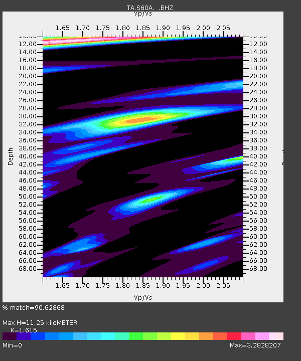
S60A Water View, VA, USA - Earthquake Result Viewer
| Earthquake location: |
Easter Island Region |
| Earthquake latitude/longitude: |
-26.6/-114.5 |
| Earthquake time(UTC): |
2014/09/06 (249) 06:53:13 GMT |
| Earthquake Depth: |
10 km |
| Earthquake Magnitude: |
6.1 MB |
| Earthquake Catalog/Contributor: |
NEIC PDE/NEIC COMCAT |
|
| Network: |
TA USArray Transportable Network (new EarthScope stations) |
| Station: |
S60A Water View, VA, USA |
| Lat/Lon: |
37.42 N/76.39 W |
| Elevation: |
36 m |
|
| Distance: |
73.1 deg |
| Az: |
30.871 deg |
| Baz: |
215.235 deg |
| Ray Param: |
0.053251885 |
| Estimated Moho Depth: |
11.25 km |
| Estimated Crust Vp/Vs: |
1.62 |
| Assumed Crust Vp: |
6.565 km/s |
| Estimated Crust Vs: |
4.065 km/s |
| Estimated Crust Poisson's Ratio: |
0.19 |
|
| Radial Match: |
90.62868 % |
| Radial Bump: |
400 |
| Transverse Match: |
80.528114 % |
| Transverse Bump: |
400 |
| SOD ConfigId: |
790520 |
| Insert Time: |
2014-09-20 07:48:42.412 +0000 |
| GWidth: |
2.5 |
| Max Bumps: |
400 |
| Tol: |
0.001 |
|

Signal To Noise
| Channel | StoN | STA | LTA |
| TA:S60A: :BHZ:20140906T07:04:12.99999Z | 9.638879 | 1.5060767E-6 | 1.562502E-7 |
| TA:S60A: :BHN:20140906T07:04:12.99999Z | 3.6465523 | 1.0343471E-6 | 2.8365068E-7 |
| TA:S60A: :BHE:20140906T07:04:12.99999Z | 1.7516307 | 4.7537728E-7 | 2.7139126E-7 |
| Arrivals |
| Ps | 1.1 SECOND |
| PpPs | 4.3 SECOND |
| PsPs/PpSs | 5.4 SECOND |


