You are here: Home > Network List > TA - USArray Transportable Network (new EarthScope stations) Stations List
> Station U40A Yellville, AR, USA > Earthquake Result Viewer
U40A Yellville, AR, USA - Earthquake Result Viewer
| Earthquake location: |
Easter Island Region |
| Earthquake latitude/longitude: |
-26.6/-114.5 |
| Earthquake time(UTC): |
2014/09/06 (249) 06:53:13 GMT |
| Earthquake Depth: |
10 km |
| Earthquake Magnitude: |
6.1 MB |
| Earthquake Catalog/Contributor: |
NEIC PDE/NEIC COMCAT |
|
| Network: |
TA USArray Transportable Network (new EarthScope stations) |
| Station: |
U40A Yellville, AR, USA |
| Lat/Lon: |
36.36 N/92.85 W |
| Elevation: |
374 m |
|
| Distance: |
65.9 deg |
| Az: |
19.005 deg |
| Baz: |
201.168 deg |
| Ray Param: |
0.05798599 |
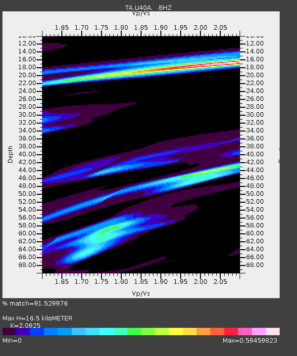
| Estimated Moho Depth: |
16.5 km |
| Estimated Crust Vp/Vs: |
2.09 |
| Assumed Crust Vp: |
6.53 km/s |
| Estimated Crust Vs: |
3.121 km/s |
| Estimated Crust Poisson's Ratio: |
0.35 |
|
| Radial Match: |
91.529976 % |
| Radial Bump: |
290 |
| Transverse Match: |
82.381836 % |
| Transverse Bump: |
400 |
| SOD ConfigId: |
790520 |
| Insert Time: |
2014-09-20 07:49:28.786 +0000 |
| GWidth: |
2.5 |
| Max Bumps: |
400 |
| Tol: |
0.001 |
|
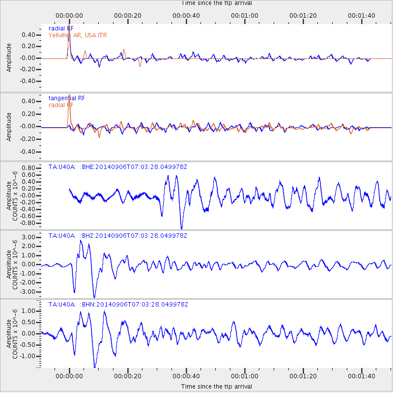
Signal To Noise
| Channel | StoN | STA | LTA |
| TA:U40A: :BHZ:20140906T07:03:28.049978Z | 16.485107 | 1.5464585E-6 | 9.380943E-8 |
| TA:U40A: :BHN:20140906T07:03:28.049978Z | 6.022657 | 5.2197834E-7 | 8.666911E-8 |
| TA:U40A: :BHE:20140906T07:03:28.049978Z | 3.517268 | 3.1287814E-7 | 8.895488E-8 |
| Arrivals |
| Ps | 2.9 SECOND |
| PpPs | 7.5 SECOND |
| PsPs/PpSs | 10 SECOND |


