You are here: Home > Network List > TA - USArray Transportable Network (new EarthScope stations) Stations List
> Station V54A Nebo, NC, USA > Earthquake Result Viewer
V54A Nebo, NC, USA - Earthquake Result Viewer
| Earthquake location: |
Easter Island Region |
| Earthquake latitude/longitude: |
-26.6/-114.5 |
| Earthquake time(UTC): |
2014/09/06 (249) 06:53:13 GMT |
| Earthquake Depth: |
10 km |
| Earthquake Magnitude: |
6.1 MB |
| Earthquake Catalog/Contributor: |
NEIC PDE/NEIC COMCAT |
|
| Network: |
TA USArray Transportable Network (new EarthScope stations) |
| Station: |
V54A Nebo, NC, USA |
| Lat/Lon: |
35.78 N/81.95 W |
| Elevation: |
448 m |
|
| Distance: |
69.2 deg |
| Az: |
27.862 deg |
| Baz: |
210.962 deg |
| Ray Param: |
0.055776425 |
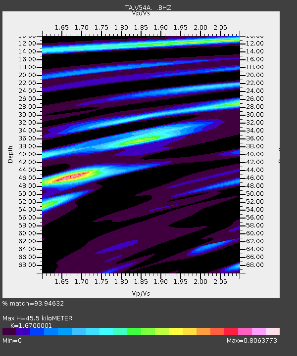
| Estimated Moho Depth: |
45.5 km |
| Estimated Crust Vp/Vs: |
1.67 |
| Assumed Crust Vp: |
6.419 km/s |
| Estimated Crust Vs: |
3.844 km/s |
| Estimated Crust Poisson's Ratio: |
0.22 |
|
| Radial Match: |
93.94632 % |
| Radial Bump: |
396 |
| Transverse Match: |
71.39545 % |
| Transverse Bump: |
400 |
| SOD ConfigId: |
790520 |
| Insert Time: |
2014-09-20 07:49:48.897 +0000 |
| GWidth: |
2.5 |
| Max Bumps: |
400 |
| Tol: |
0.001 |
|

Signal To Noise
| Channel | StoN | STA | LTA |
| TA:V54A: :BHZ:20140906T07:03:49.299978Z | 13.551624 | 1.6834202E-6 | 1.2422277E-7 |
| TA:V54A: :BHN:20140906T07:03:49.299978Z | 6.5824566 | 6.8410446E-7 | 1.0392844E-7 |
| TA:V54A: :BHE:20140906T07:03:49.299978Z | 2.863113 | 2.9893016E-7 | 1.044074E-7 |
| Arrivals |
| Ps | 4.9 SECOND |
| PpPs | 18 SECOND |
| PsPs/PpSs | 23 SECOND |


