You are here: Home > Network List > TA - USArray Transportable Network (new EarthScope stations) Stations List
> Station V59A Middlesex, NC, USA > Earthquake Result Viewer
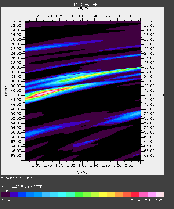
V59A Middlesex, NC, USA - Earthquake Result Viewer
| Earthquake location: |
Easter Island Region |
| Earthquake latitude/longitude: |
-26.6/-114.5 |
| Earthquake time(UTC): |
2014/09/06 (249) 06:53:13 GMT |
| Earthquake Depth: |
10 km |
| Earthquake Magnitude: |
6.1 MB |
| Earthquake Catalog/Contributor: |
NEIC PDE/NEIC COMCAT |
|
| Network: |
TA USArray Transportable Network (new EarthScope stations) |
| Station: |
V59A Middlesex, NC, USA |
| Lat/Lon: |
35.76 N/78.24 W |
| Elevation: |
58 m |
|
| Distance: |
70.9 deg |
| Az: |
30.574 deg |
| Baz: |
214.046 deg |
| Ray Param: |
0.054707125 |
| Estimated Moho Depth: |
40.5 km |
| Estimated Crust Vp/Vs: |
1.70 |
| Assumed Crust Vp: |
6.565 km/s |
| Estimated Crust Vs: |
3.861 km/s |
| Estimated Crust Poisson's Ratio: |
0.24 |
|
| Radial Match: |
96.4548 % |
| Radial Bump: |
266 |
| Transverse Match: |
82.28145 % |
| Transverse Bump: |
400 |
| SOD ConfigId: |
790520 |
| Insert Time: |
2014-09-20 07:49:58.051 +0000 |
| GWidth: |
2.5 |
| Max Bumps: |
400 |
| Tol: |
0.001 |
|

Signal To Noise
| Channel | StoN | STA | LTA |
| TA:V59A: :BHZ:20140906T07:03:59.150015Z | 16.875961 | 1.4538819E-6 | 8.6151054E-8 |
| TA:V59A: :BHN:20140906T07:03:59.150015Z | 7.066407 | 5.0606866E-7 | 7.1616114E-8 |
| TA:V59A: :BHE:20140906T07:03:59.150015Z | 6.115006 | 4.6124342E-7 | 7.542812E-8 |
| Arrivals |
| Ps | 4.5 SECOND |
| PpPs | 16 SECOND |
| PsPs/PpSs | 21 SECOND |


