You are here: Home > Network List > TA - USArray Transportable Network (new EarthScope stations) Stations List
> Station V62A Hyde County Airport, Englehard, NC, USA > Earthquake Result Viewer
V62A Hyde County Airport, Englehard, NC, USA - Earthquake Result Viewer

| Earthquake location: |
Easter Island Region |
| Earthquake latitude/longitude: |
-26.6/-114.5 |
| Earthquake time(UTC): |
2014/09/06 (249) 06:53:13 GMT |
| Earthquake Depth: |
10 km |
| Earthquake Magnitude: |
6.1 MB |
| Earthquake Catalog/Contributor: |
NEIC PDE/NEIC COMCAT |
|
| Network: |
TA USArray Transportable Network (new EarthScope stations) |
| Station: |
V62A Hyde County Airport, Englehard, NC, USA |
| Lat/Lon: |
35.56 N/75.96 W |
| Elevation: |
-3.0 m |
|
| Distance: |
71.8 deg |
| Az: |
32.305 deg |
| Baz: |
215.926 deg |
| Ray Param: |
0.05411758 |
| Estimated Moho Depth: |
26.0 km |
| Estimated Crust Vp/Vs: |
2.10 |
| Assumed Crust Vp: |
5.738 km/s |
| Estimated Crust Vs: |
2.736 km/s |
| Estimated Crust Poisson's Ratio: |
0.35 |
|
| Radial Match: |
88.98897 % |
| Radial Bump: |
400 |
| Transverse Match: |
65.18842 % |
| Transverse Bump: |
400 |
| SOD ConfigId: |
790520 |
| Insert Time: |
2014-09-20 07:50:07.401 +0000 |
| GWidth: |
2.5 |
| Max Bumps: |
400 |
| Tol: |
0.001 |
|
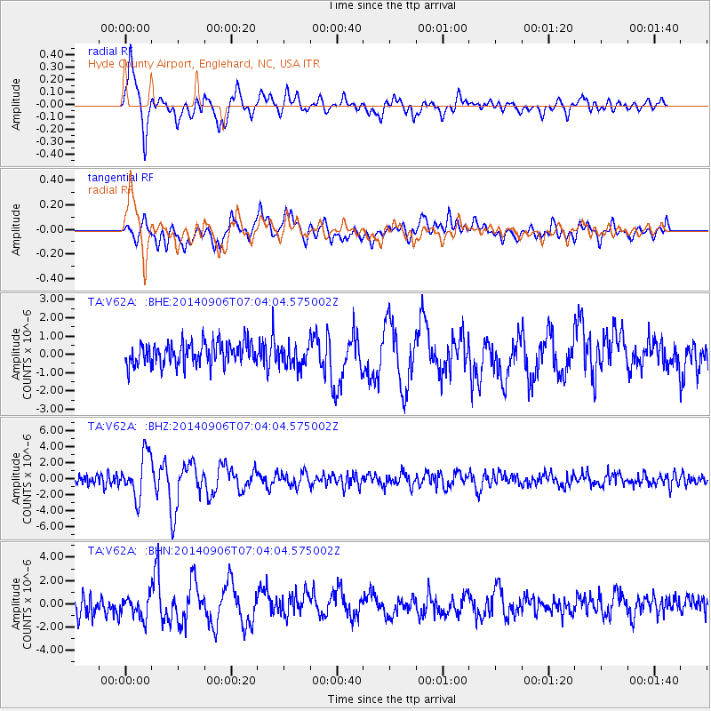
Signal To Noise
| Channel | StoN | STA | LTA |
| TA:V62A: :BHZ:20140906T07:04:04.575002Z | 5.362321 | 2.7132348E-6 | 5.0598146E-7 |
| TA:V62A: :BHN:20140906T07:04:04.575002Z | 1.4120065 | 9.82919E-7 | 6.961151E-7 |
| TA:V62A: :BHE:20140906T07:04:04.575002Z | 0.9985268 | 6.0946246E-7 | 6.1036167E-7 |
| Arrivals |
| Ps | 5.1 SECOND |
| PpPs | 14 SECOND |
| PsPs/PpSs | 19 SECOND |


