You are here: Home > Network List > TA - USArray Transportable Network (new EarthScope stations) Stations List
> Station Z41A Richland Creek Farm, El Dorado, AR, USA > Earthquake Result Viewer
Z41A Richland Creek Farm, El Dorado, AR, USA - Earthquake Result Viewer
| Earthquake location: |
Easter Island Region |
| Earthquake latitude/longitude: |
-26.6/-114.5 |
| Earthquake time(UTC): |
2014/09/06 (249) 06:53:13 GMT |
| Earthquake Depth: |
10 km |
| Earthquake Magnitude: |
6.1 MB |
| Earthquake Catalog/Contributor: |
NEIC PDE/NEIC COMCAT |
|
| Network: |
TA USArray Transportable Network (new EarthScope stations) |
| Station: |
Z41A Richland Creek Farm, El Dorado, AR, USA |
| Lat/Lon: |
33.26 N/92.80 W |
| Elevation: |
62 m |
|
| Distance: |
63.0 deg |
| Az: |
20.301 deg |
| Baz: |
201.757 deg |
| Ray Param: |
0.059853222 |
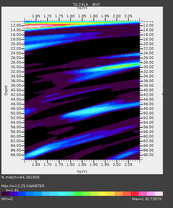
| Estimated Moho Depth: |
12.25 km |
| Estimated Crust Vp/Vs: |
1.61 |
| Assumed Crust Vp: |
6.245 km/s |
| Estimated Crust Vs: |
3.879 km/s |
| Estimated Crust Poisson's Ratio: |
0.19 |
|
| Radial Match: |
94.381905 % |
| Radial Bump: |
400 |
| Transverse Match: |
66.07793 % |
| Transverse Bump: |
400 |
| SOD ConfigId: |
790520 |
| Insert Time: |
2014-09-20 07:52:26.862 +0000 |
| GWidth: |
2.5 |
| Max Bumps: |
400 |
| Tol: |
0.001 |
|
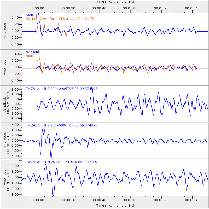
Signal To Noise
| Channel | StoN | STA | LTA |
| TA:Z41A: :BHZ:20140906T07:03:09.37499Z | 17.655285 | 2.661837E-6 | 1.5076715E-7 |
| TA:Z41A: :BHN:20140906T07:03:09.37499Z | 1.9176415 | 7.005748E-7 | 3.6533146E-7 |
| TA:Z41A: :BHE:20140906T07:03:09.37499Z | 1.6754415 | 5.434383E-7 | 3.2435528E-7 |
| Arrivals |
| Ps | 1.3 SECOND |
| PpPs | 4.9 SECOND |
| PsPs/PpSs | 6.1 SECOND |


