You are here: Home > Network List > US - United States National Seismic Network Stations List
> Station COWI Conover, Wisconsin, USA > Earthquake Result Viewer
COWI Conover, Wisconsin, USA - Earthquake Result Viewer
| Earthquake location: |
Easter Island Region |
| Earthquake latitude/longitude: |
-26.6/-114.5 |
| Earthquake time(UTC): |
2014/09/06 (249) 06:53:13 GMT |
| Earthquake Depth: |
10 km |
| Earthquake Magnitude: |
6.1 MB |
| Earthquake Catalog/Contributor: |
NEIC PDE/NEIC COMCAT |
|
| Network: |
US United States National Seismic Network |
| Station: |
COWI Conover, Wisconsin, USA |
| Lat/Lon: |
46.10 N/89.14 W |
| Elevation: |
523 m |
|
| Distance: |
75.9 deg |
| Az: |
17.864 deg |
| Baz: |
203.243 deg |
| Ray Param: |
0.051327392 |
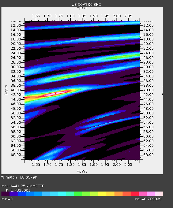
| Estimated Moho Depth: |
41.25 km |
| Estimated Crust Vp/Vs: |
1.73 |
| Assumed Crust Vp: |
6.467 km/s |
| Estimated Crust Vs: |
3.733 km/s |
| Estimated Crust Poisson's Ratio: |
0.25 |
|
| Radial Match: |
88.05799 % |
| Radial Bump: |
400 |
| Transverse Match: |
77.922066 % |
| Transverse Bump: |
400 |
| SOD ConfigId: |
790520 |
| Insert Time: |
2014-09-20 07:53:48.621 +0000 |
| GWidth: |
2.5 |
| Max Bumps: |
400 |
| Tol: |
0.001 |
|
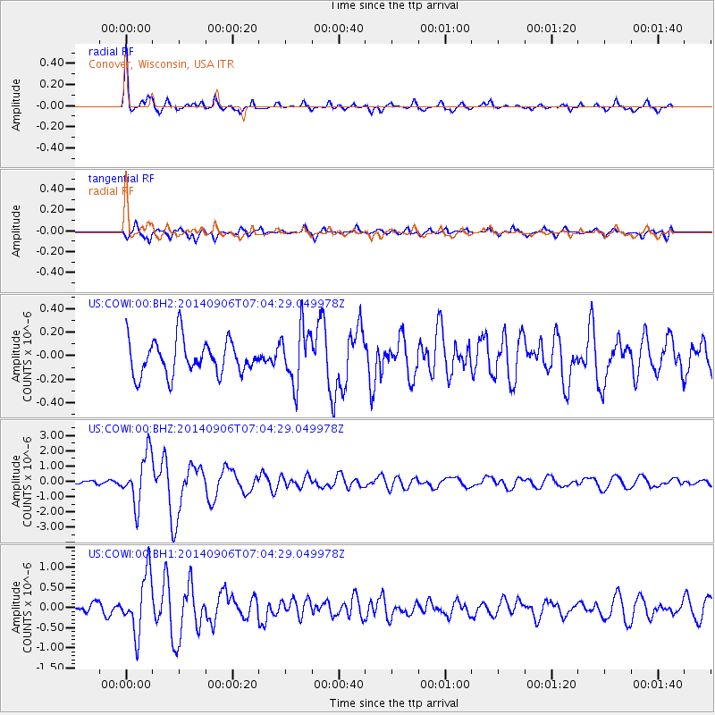
Signal To Noise
| Channel | StoN | STA | LTA |
| US:COWI:00:BHZ:20140906T07:04:29.049978Z | 13.545218 | 1.6476332E-6 | 1.2163947E-7 |
| US:COWI:00:BH1:20140906T07:04:29.049978Z | 7.438492 | 7.3367977E-7 | 9.863286E-8 |
| US:COWI:00:BH2:20140906T07:04:29.049978Z | 1.6439036 | 2.3842864E-7 | 1.4503809E-7 |
| Arrivals |
| Ps | 4.8 SECOND |
| PpPs | 17 SECOND |
| PsPs/PpSs | 22 SECOND |


