You are here: Home > Network List > US - United States National Seismic Network Stations List
> Station NEW Newport, Washington, USA > Earthquake Result Viewer
NEW Newport, Washington, USA - Earthquake Result Viewer
| Earthquake location: |
Easter Island Region |
| Earthquake latitude/longitude: |
-26.6/-114.5 |
| Earthquake time(UTC): |
2014/09/06 (249) 06:53:13 GMT |
| Earthquake Depth: |
10 km |
| Earthquake Magnitude: |
6.1 MB |
| Earthquake Catalog/Contributor: |
NEIC PDE/NEIC COMCAT |
|
| Network: |
US United States National Seismic Network |
| Station: |
NEW Newport, Washington, USA |
| Lat/Lon: |
48.26 N/117.12 W |
| Elevation: |
760 m |
|
| Distance: |
74.6 deg |
| Az: |
358.154 deg |
| Baz: |
177.526 deg |
| Ray Param: |
0.052236605 |
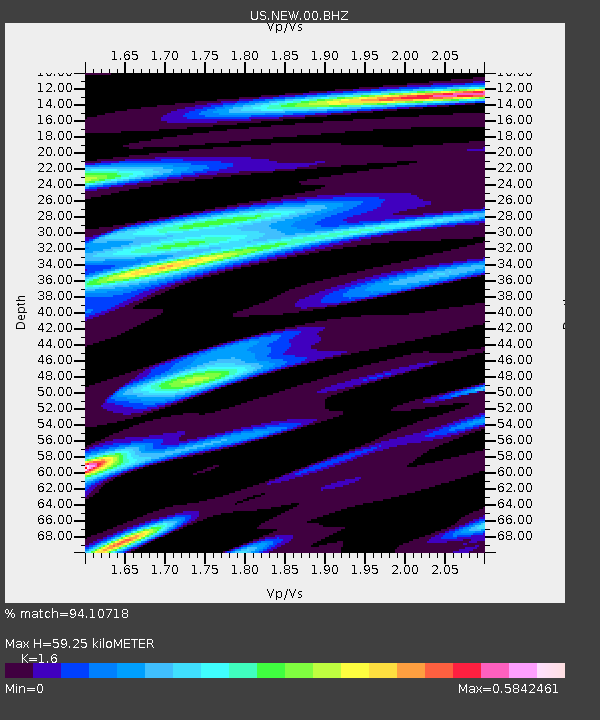
| Estimated Moho Depth: |
59.25 km |
| Estimated Crust Vp/Vs: |
1.60 |
| Assumed Crust Vp: |
6.571 km/s |
| Estimated Crust Vs: |
4.107 km/s |
| Estimated Crust Poisson's Ratio: |
0.18 |
|
| Radial Match: |
94.10718 % |
| Radial Bump: |
311 |
| Transverse Match: |
82.59131 % |
| Transverse Bump: |
400 |
| SOD ConfigId: |
790520 |
| Insert Time: |
2014-09-20 07:54:58.882 +0000 |
| GWidth: |
2.5 |
| Max Bumps: |
400 |
| Tol: |
0.001 |
|

Signal To Noise
| Channel | StoN | STA | LTA |
| US:NEW:00:BHZ:20140906T07:04:21.24999Z | 18.839045 | 1.6814896E-6 | 8.9255565E-8 |
| US:NEW:00:BH1:20140906T07:04:21.24999Z | 7.05582 | 5.9812766E-7 | 8.477082E-8 |
| US:NEW:00:BH2:20140906T07:04:21.24999Z | 2.6561425 | 2.2755594E-7 | 8.567159E-8 |
| Arrivals |
| Ps | 5.6 SECOND |
| PpPs | 23 SECOND |
| PsPs/PpSs | 28 SECOND |


