You are here: Home > Network List > US - United States National Seismic Network Stations List
> Station TPNV Topopah Spring, Nevada, USA > Earthquake Result Viewer
TPNV Topopah Spring, Nevada, USA - Earthquake Result Viewer
| Earthquake location: |
Easter Island Region |
| Earthquake latitude/longitude: |
-26.6/-114.5 |
| Earthquake time(UTC): |
2014/09/06 (249) 06:53:13 GMT |
| Earthquake Depth: |
10 km |
| Earthquake Magnitude: |
6.1 MB |
| Earthquake Catalog/Contributor: |
NEIC PDE/NEIC COMCAT |
|
| Network: |
US United States National Seismic Network |
| Station: |
TPNV Topopah Spring, Nevada, USA |
| Lat/Lon: |
36.95 N/116.25 W |
| Elevation: |
1600 m |
|
| Distance: |
63.3 deg |
| Az: |
358.391 deg |
| Baz: |
178.202 deg |
| Ray Param: |
0.05969337 |
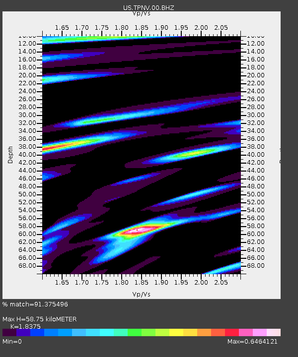
| Estimated Moho Depth: |
58.75 km |
| Estimated Crust Vp/Vs: |
1.84 |
| Assumed Crust Vp: |
6.279 km/s |
| Estimated Crust Vs: |
3.417 km/s |
| Estimated Crust Poisson's Ratio: |
0.29 |
|
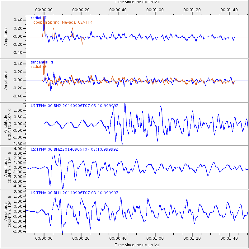
| Radial Match: |
91.375496 % |
| Radial Bump: |
400 |
| Transverse Match: |
81.2751 % |
| Transverse Bump: |
400 |
| SOD ConfigId: |
790520 |
| Insert Time: |
2014-09-20 07:55:15.447 +0000 |
| GWidth: |
2.5 |
| Max Bumps: |
400 |
| Tol: |
0.001 |
|
Signal To Noise
| Channel | StoN | STA | LTA |
| US:TPNV:00:BHZ:20140906T07:03:10.99999Z | 18.588701 | 1.5457952E-6 | 8.315778E-8 |
| US:TPNV:00:BH1:20140906T07:03:10.99999Z | 6.4613476 | 5.582029E-7 | 8.639109E-8 |
| US:TPNV:00:BH2:20140906T07:03:10.99999Z | 1.443067 | 2.2788636E-7 | 1.5791808E-7 |
| Arrivals |
| Ps | 8.2 SECOND |
| PpPs | 26 SECOND |
| PsPs/PpSs | 34 SECOND |


